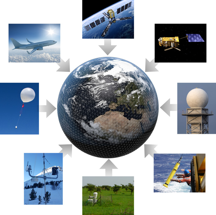

The ocean surface, the ocean subsurface and sea-ice conditions are relevant to forecasting at all time ranges (including medium-range, sub-seasonal and seasonal). (© AlbertMi/iStock/Getty Images Plus)
In the natural Earth system there is continuous interaction between the atmosphere, ocean, cryosphere and land. Improvement in weather forecast skill depends on accurate information on all four domains.
Ocean observations in particular were the focus of a WMO technical workshop held in Geneva on 5 and 6 February 2019, to which ECMWF contributed.
Earth system observing systems
The ocean surface, the ocean subsurface and sea-ice conditions are relevant to forecasting at all time ranges (including medium-range, sub-seasonal and seasonal). Improved coupling of the atmosphere with the ocean is a key component of the development strategy for numerical weather prediction (NWP) over the next several years and features strongly in the ECMWF Strategy 2016–2025.
Including ocean processes contributes to the ability to forecast tropical cyclone tracks and intensity, heatwaves, cold spells and seasonal temperature anomalies. Observation and model developments are now focusing on improving the physical description and initialisation of interactions between the atmosphere, ocean, sea ice and land.

Earth system modelling needs accurate information from a wide range of observing systems, including satellites, radar, ocean floats and buoys, weather stations, weather balloons and aircraft. (Image credits below)
The Earth system approach requires an increasing amount of quality information about the ocean, land, ice and the atmosphere from long-term sustainable observing systems. Free and unrestricted exchange of such observations is critical.
ECMWF is working with the WMO to address the requirements for Earth system observations within the WMO Integrated Global Observing System (WIGOS) framework, the World Weather Watch (WWW), the Global Atmosphere Watch (GAW), the Global Cryosphere Watch (GCW), and the Global Ocean Observing System (GOOS).
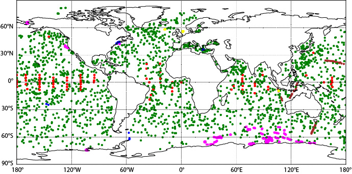
Weather forecasting is a major driver of marine observations and services. Ocean observations are collected from different platforms, such as Ships of Opportunity, drifting buoys, tethered buoys, profiling floats, unmanned surface and underwater vehicles, and remote sensing by satellites.
We are seeing rapid developments in observing technologies to take higher resolution observations, measure remote parts of the ocean, and measure more variables, as well as the development of cheaper, easier to use observing equipment.

Typical in-situ ocean observation coverage used for the initialisation of the ocean subsurface in the ECMWF coupled forecasting systems. The Argo floats (green) provide uniform global coverage of temperature and salinity. The tropical mooring array (red) samples the three tropical ocean basins. Also shown are the XBTs from Ships of Opportunity (brown) and CTDs from research cruises (blue). Observations from marine mammals are shown in magenta and from seagliders in yellow.
User requirements for observations
The WIGOS Rolling Requirements Review (RRR) process is managed by the WMO Commission for Basic Systems (CBS) Inter Programme Expert Team on Observing System Design and Evolution (IPET-OSDE). The RRR process helps to ensure that the WIGOS meets the requirements of WMO programmes, and evolves according to user needs.
Requirements are systematically gathered and stored in the OSCAR/Requirements database. Gaps with respect to the actual capabilities of WIGOS are analysed and discussed in Statements of Guidance. The gap analysis feeds into the Implementation plan towards realising the Vision for global observing systems.
The following issues have been identified:
- Data availability where observations exist but are not being shared with WMO
- Reducing the time it takes for observations to become available for assimilation in models
- Assuring required coverage of ocean observing networks (e.g. tropical moored buoys and new Tropical Pacific Observing System 2020 design)
Using observations to the full
Realising the societal benefits of improved forecasts depends on utilising these observations in the different stages of the forecasting system: in data assimilation for initialising forecasts; for understanding processes to improve coupled prediction systems; for evaluating and verifying forecast skill; and for quantifying uncertainty.
The NWP process adds value to the observations. Weather services communicate the resulting information to decision-makers, policy-makers and other end users for the prevention of loss of life and property.
“Enhancing ocean observations and research, and the free exchange of data, to foster services for the safety of life and property” was the topic of a WMO Technical Workshop held in Geneva on 5 and 6 February 2019. The workshop report concluded that information needs to be gathered and communicated on how and where observations make a positive impact on forecasts and warning systems.
An OECD study is under way to estimate the economic value of sustained observing globally, including of coastal regions, which could be helpful in demonstrating the value of data sharing. Traditional Observing System Experiments were also recommended as a means to demonstrate and highlight the value of ocean observations.
More information about WIGOS is available in the article ‘How to evolve global observing systems’.
Image credits for Earth system observing systems, clockwise from top: SMOS satellite: © ESA/AOES Medialab; Metop satellite: © EUMETSAT; Radar station: © next143/iStock/Getty Images Plus; Argo float: © CSIRO; Weather station: © Patricia de Rosnay; Snow station: © Patricia de Rosnay; Weather balloon: © Gwenvidig/iStock/Getty Images Plus; Aircraft: © kafl/iStock/Getty Images Plus.
