
ECMWF launched a new model cycle on 12 May bringing a range of improvements to its Integrated Forecasting System (IFS).
Changes in the ways in which observations are assimilated and atmospheric processes are modelled have been shown to improve the representation of the current state of the atmosphere as well as the skill of forecasts. IFS Cycle 41r1 replaces Cycle 40r1, which was introduced in November 2013.
The new model cycle brings consistent gains in forecast performance at the surface for total cloud cover and precipitation. Improvements in the modelling of cloud and precipitation reduce the occurrence of drizzle in forecasts of rainfall from extensive sheets of cloud, and they increase the amount of precipitation in forecasts of heavy rainfall, leading to a better match with observations.
Improvements are also seen for 2-metre temperature and 2-metre humidity in parts of the northern hemisphere and the tropics.
Cycle 41r1 also introduces a number of new output parameters, such as precipitation type, including freezing rain. The first figure shows how this can lead to significant improvements in forecasts.

Freezing rain event in Slovenia and Croatia on 2 February 2014. The panels show observed precipitation type (left); precipitation type and rate (mm/hour) forecast by IFS Cycle 40r1 (middle); and precipitation type and rate forecast with the new physics implemented in IFS Cycle 41r1 (right).
The new model cycle improves both high-resolution forecasts (HRES), in which the model is run on a fine mesh of grid points spanning the globe, and ensemble forecasts (ENS), which use a coarser mesh. Together, they predict a set of possible outcomes, taking into account uncertainties arising from our imperfect knowledge of the current state of the atmosphere and from limitations in the forecasting model.
The average position error for tropical cyclones is slightly reduced, and tropical cyclones are generally forecast to be more intense. The second figure shows that IFS Cycle 41r1 performed better than Cycle 40r1 in predicting the track of tropical cyclone Pam, which devastated Vanuatu in the South Pacific in March 2015.
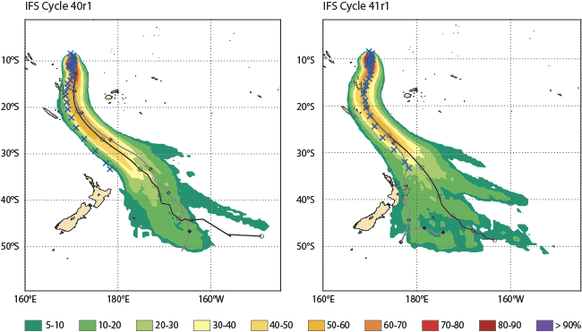
Tropical cyclone tracks. The shaded areas in the two panels show the predicted probability of Pam passing within a 120 km radius over the next 240 hours, starting from its position about 10° South and 170° East on 10 March. The blue crosses show the observed track, the black line represents the ENS mean forecast and the grey line the HRES forecast.
Cycle 41r1 also introduces a lake model which will improve 2-metre temperature forecasts in the vicinity of small lakes not represented in the previous model.
A range of additional satellite observations will improve the representation of land surface, sea ice and ocean wave parameters. Ocean wave forecasts will also benefit from the extension of the high-resolution wave model from the European and North Atlantic region to the whole of the globe.
The new model cycle is described in greater detail on the Cycle 41r1 page.