
ECMWF has extended its weather observation monitoring system to ocean observations and has begun to publish the results on its website.
Observation monitoring provides vital information on the availability and quality of weather observations from satellites, weather stations, aircraft and other sources.
ECMWF has extended it to cover not just the ocean but also the land surface in order to support coupled data assimilation developments.
This is in line with the Centre’s recently adopted 10-year Strategy, which calls for all relevant Earth system interactions to be taken into account to achieve ECMWF’s long-term goals.
The routine monitoring of observations is a key element in diagnosing data assimilation systems.
It serves to optimise the use made of observations and ultimately to improve the initial conditions on which forecasts are based.
Monitoring results also provide data providers with important information as they highlight problematic observations and offer valuable guidance for the design of future observing systems.
Finally, sharing monitoring results is very useful for numerical weather prediction centres as a way of comparing statistics and identifying weaknesses in each system.

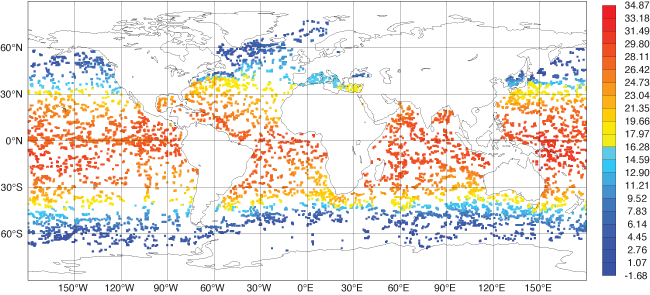
This observation monitoring map shows the mean potential temperature (in °C) of the first 5 metres of the ocean as measured by Argo floats over the period 1 February 2017 to 27 March 2017.
ECMWF now monitors all observations processed by the atmospheric, land surface and ocean data assimilation systems. A comprehensive set of statistics is publicly available from our observing system monitoring web page.
The following ocean observations are monitored:
- Profiles of potential temperature from the Argo fleet, moored buoys, CTD devices and XBT thermographs
- Profiles of salinity from the Argo fleet, moored buoys and CTD devices
- Sea-level anomaly provided by altimeters. Currently observations are provided by Cryosat, Jason 2, Jason 3 and Saral/Altika
- Sea-ice concentration from the UK Met Office's OSTIA product.
Monitoring statistics include a range of quantities indicative of the availability and quality of observations and of the magnitude of adjustments applied by the data assimilation system. Statistics are presented in various formats allowing the exploration of observations from different perspectives (for example time, depth, area).
|
|
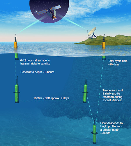
Thousands of Argo floats provide a high-density observation network across the globe for ocean parameters to a depth of 2,000 metres. When they surface, their measurements are beamed to a satellite, from where they are transmitted to ground stations. The Argo array is part of the Global Climate Observing System/Global Ocean Observing System GCOS /GOOS. (Graphic: Mathieu Belbéoch)
|
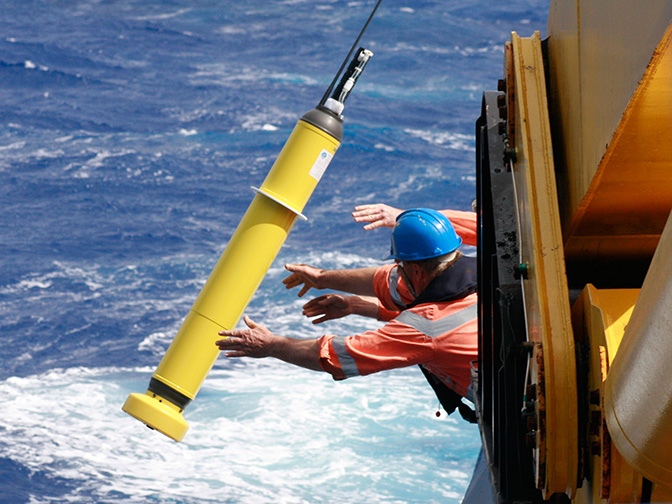
Top image: An Argo float is deployed into the ocean. (Photo: CSIRO)

