
Accurate and timely Earth system observations from across the globe are essential for high-quality weather forecasts.
EUMETSAT satellites are playing an ever-growing role in providing them.
A major development on the horizon is the deployment of new capabilities to observe detailed layer characteristics of the atmosphere continuously from geostationary orbit.
New satellites to be operated by EUMETSAT will also support two EU-funded Earth observation services operated by ECMWF: the Copernicus Climate Change Service (C3S) and the Copernicus Atmosphere Monitoring Service (CAMS).
Why satellites?
If we want to know what the global weather will be tomorrow or next week, we first need to know the state of the atmosphere and related parts of the Earth system today. Only then can we calculate how the weather is likely to evolve, given the laws of physics.
ECMWF’s new ten-year Strategy includes ambitious goals, such as making skilful predictions of high-impact weather up to two weeks ahead.
One way to push the limits of predictability is to get better at assessing the current state of the atmosphere, the land, the oceans and sea ice across the globe.
It’s a tall order. In practice it cannot be done without satellites.
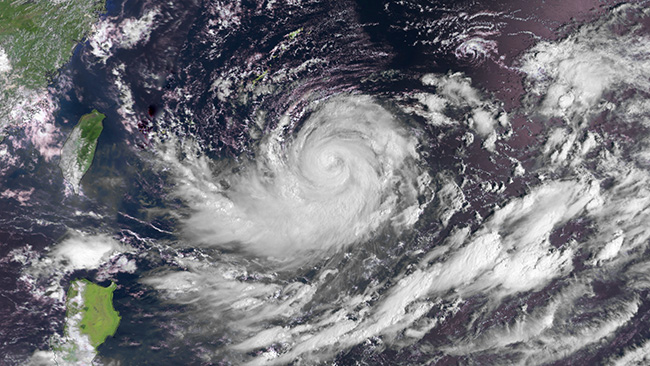
Satellites can be used to track storms such as this category-three typhoon near Okinawa, Japan. Typhoon Lionrock was captured by EUMETSAT's Metop-B polar-orbiting satellite at 00:52 UTC on Thursday 26 August 2016. Metop-B is part of a series of three polar-orbiting meteorological satellites in the EUMETSAT Polar System (EPS). The last in the series, Metop-C, is due to be launched in 2018. To ensure the continuity of observations and respond to user needs in the time frame 2020–2040, two second-generation series of EPS satellites (EPS-SG), Metop-SG A and Metop-SG B, are due to be launched from 2021. (Copyright: 2016 EUMETSAT)
Every day ECMWF uses tens of millions of satellite observations. They come from space agencies across the world, including in particular our sister organisation EUMETSAT.
New instruments and better ways of interpreting the data continue to pave the way for better forecasts.
That is why ECMWF’s partnership with EUMETSAT is so important.
“New satellites to be launched over the next ten years will bring huge improvements to our ability to observe the Earth’s atmosphere and oceans,” says EUMETSAT Director-General Alain Ratier.
“Requirements for these systems have been established in close collaboration with ECMWF and other users to meet their evolving needs, and ECMWF is contributing to scientific aspects of their development. This ensures that society will gain maximum benefit from these new capabilities in the form of improved weather forecasts and Copernicus services.”
New observations
A big change will come with the launch of the geostationary Meteosat Third Generation (MTG) satellites from 2021.
For the first time they will provide a continuous stream of detailed vertical layer-by-layer information on water vapour, wind and temperature by means of the newly developed Infrared Sounder (IRS).
This ‘hyperspectral’ instrument will measure thermal radiation emitted from the atmosphere at very high spectral resolution.
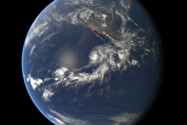
Hurricane Andres off the west coast of the USA as seen by geostationary satellites on 1 June 2015 at 00:00 UTC. The image was obtained by overlaying infrared data from EUMETSAT and NOAA satellites over a computer-generated model of the Earth using NASA's Blue Marble Next Generation imagery. (Copyright: 2015 EUMETSAT)
At the moment only polar-orbiting satellites carry hyperspectral instruments capable of providing detailed vertical layer-by-layer information.
“Polar-orbiting satellites build up a three dimensional picture of the atmosphere by repeatedly circling the globe, but the drawback is that they may observe a particular area only once or twice per day,” ECMWF scientist Tony McNally explains.
Geostationary satellites are located high above the equator and continuously observe the large circular region of the Earth below.
“Combining continuous coverage from geostationary satellites with the deployment of hyperspectral instruments will greatly benefit numerical weather prediction (NWP),” Dr McNally says.
EUMETSAT is also responsible for operating the Sentinel satellites devoted to monitoring the atmosphere and oceans as part of the EU’s Copernicus Earth observation programme.
Some of these satellites, such as Sentinel-3A, have already been deployed, others are scheduled to go into orbit over the next few years.
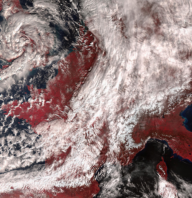
Europe as seen by Sentinel-3A’s Sea and Land Surface Temperature Radiometer (SLSTR) on 2 March 2016 at 10:04 UTC. Vegetated areas are shown in red. The weather system over the UK is storm Jake. The Sentinel-3 satellites are polar-orbiting satellites flying at an altitude of about 815 km. (Copernicus Sentinel Data 2016)
Data from these missions will be invaluable for the ECMWF-run Copernicus Climate Change and Atmosphere Monitoring Services.
Close collaboration
ECMWF collaborates very closely with EUMETSAT in a number of ways.
At any given time several EUMETSAT-funded Fellows work at ECMWF, where they gain expertise in exploiting satellite observations for NWP in an operational environment.
“As a EUMETSAT Fellow, I monitored and developed the assimilation of water vapour channels from geostationary satellites,” says Julie Letertre-Danczak, whose Fellowship ended last year and who now continues to work at the Centre.
“When new instruments are deployed, we have to estimate the quality of the new data and establish the impact on forecasts,” she explains.
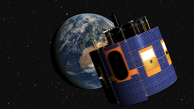
Geostationary satellites, such as this Meteosat Second Generation satellite, are in orbit nearly 36,000 km above the Earth’s equator. (Copyright: 2012 EUMETSAT)
ECMWF also participates as part of a consortium of agencies in the EUMETSAT Satellite Application Facility (SAF) network. The SAF ensures that the observations and products generated by EUMETSAT satellites are useful to operational centres by providing assimilation tools and training in their exploitation.
Annual bilateral meetings between ECMWF and EUMETSAT are used to review existing areas of collaboration between the two agencies and to explore new opportunities.
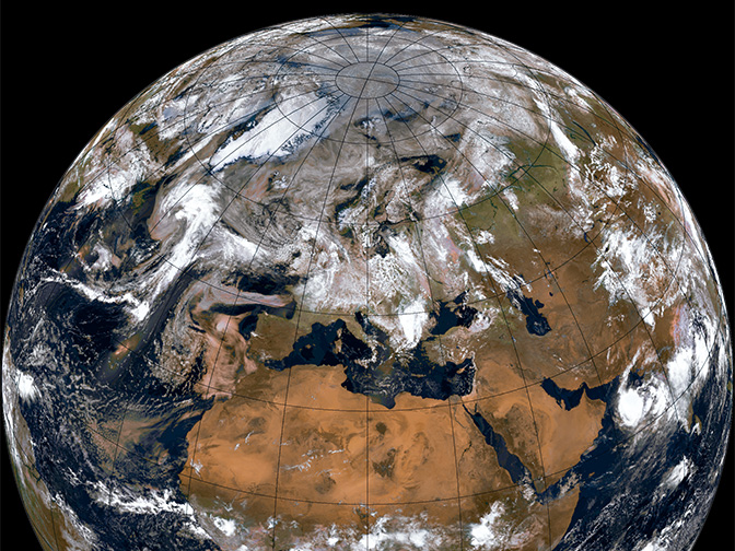
Top image: Composite image of Earth as seen from EUMETSAT’s Metop-B weather satellite in polar orbit at an altitude of 817 km. (Copyright: 2016 EUMETSAT)
