
An upgrade of ECMWF’s Integrated Forecasting System (IFS) implemented on 11 July improves forecast skill in medium-range and monthly forecasts.
IFS Cycle 43r3 includes changes in the model and in the assimilation of weather observations.
Model changes include a new radiation scheme, improvements in the modelling of convection and a new aerosol climatology.
Changes in data assimilation and in the way dropsonde observations are handled have improved the accuracy of the initial conditions on which forecasts are based. This is especially true of tropical cyclones.
The IFS is upgraded regularly, typically once or twice a year, to implement improvements made possible by the latest scientific advances.
Better use of observations
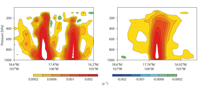
Previously tropical cyclones were occasionally represented as having an unrealistic structure, such as a double centre. The upgrade has resolved this issue, notably through a more cautious use of dropsonde wind observations.
As a result, the quality of forecasts has improved. At forecast day one there is a slight improvement in position error, and tropical cyclone intensity as measured by central pressure is slightly reduced from day two onwards.
This has a beneficial effect for lead times beyond four days since it reduces the existing negative bias in tropical cyclone central pressure at that range.

High-resolution analysis of relative vorticity (cross section) for Hurricane Patricia at 12 UTC on 23 October 2015 produced using the previous IFS cycle, 43r1 (left), and IFS Cycle 43r3 (right). The upgrade has removed the unrealistic double-core structure.
Other changes include an increased use of microwave humidity sounding data and improvements in the use of existing data.
The Global Precipitation Measurement Microwave Imager (GMI) humidity-sounding channels have been activated along with SAPHIR (Sounder for Atmospheric Profiling of Humidity in the Inter-tropical Regions), a humidity sounder with frequent tropical coverage.
Model changes
Changes in the model include a new, more efficient radiation scheme with reduced noise and a more accurate longwave radiation transfer calculation.
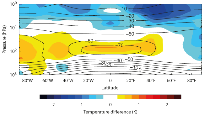
The new scheme is up to 35% faster than the old one. The longwave calculation change reduces extreme values in the temperature profile. This means the tropopause is now warmer and the stratopause is now cooler in the model, reducing the existing bias in both locations.

Difference in zonal (west–east) mean temperature between the new radiation scheme and the previous one (IFS Cycle 43r3 minus IFS Cycle 43r1 – shading) for a four-year coupled climate simulation. The contours show temperature in °C according to the climate simulation using IFS Cycle 43r3. The upgrade reduces the existing bias in the tropopause and the stratopause.
Improvements have also been made in the treatment of microphysical processes in the modelling of convection. This includes an increased amount of super-cooled liquid water at colder temperatures, leading to improved tropospheric forecast skill.
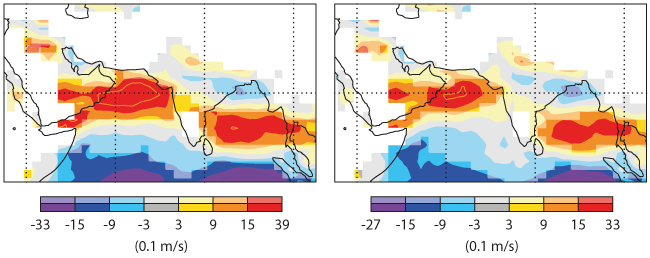
Finally, a new aerosol climatology, derived from data provided by the ECMWF-run Copernicus Atmosphere Monitoring Service (CAMS), leads to an improved representation of the Indian summer monsoon, which is currently too strong in the IFS.
This is an example of how Copernicus, the EU’s flagship Earth observation programme, can help to improve the IFS by providing data on various Earth system components relevant to numerical weather prediction.

Bias in the day-5 forecast of 925 hPa zonal wind in the Indian monsoon region in summer (June–August) for the previous IFS cycle, 43r1 (left), and IFS Cycle 43r3 with the new aerosol climatology (right). Saturated colours indicate areas where the signal is significant at the 95% confidence level.
Main impacts
The changes have a positive impact on both the high-resolution forecast (HRES) and the medium-range/monthly ensemble (ENS).
Ensemble forecasts describe the range of possible weather scenarios and their likelihood of occurrence.
Many of the scores over the northern and southern hemispheres and Europe show statistically significant improvements, especially in summer.
The convection scheme changes have improved the temperature gradient between the extratropics and the tropics.
Significant improvements are found for temperature and vector wind throughout the extratropical troposphere.
In the tropics, there is some deterioration in temperature and humidity at certain vertical levels associated with the changes to the convection scheme.
Over the ocean, statistically significant improvements are seen for verification against the analysis for 10-metre wind speed, significant wave height and mean wave period.
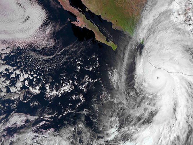
Top image: Hurricane Patricia closing in on the Pacific coast of Mexico, as seen by EUMETSAT’s Metop-B satellite on 23 October 2015. (Copyright: 2015 EUMETSAT)
