
An upgrade of ECMWF’s Integrated Forecasting System (IFS) to Cycle 48r1 implemented on 27 June has substantially improved the skill of the Centre’s weather predictions and has increased the resolution of medium-range ensemble forecasts.
The horizontal resolution of medium-range ensemble forecasts (ENS) has increased from 18 to 9 km, which is the same resolution as the current high-resolution forecast (HRES). In the future, HRES and the unperturbed control forecast of the ensemble will be merged.
In addition, configuration changes for the extended-range ensemble forecast result in substantial improvements in forecast skill and utility for users.
There have been many other changes in the forecast model and in data assimilation, leading to much-improved skill scores. The largest forecast skill improvements are associated with the ensemble forecasts because of the ENS resolution upgrade. For example, most ENS scores of surface variables are improved by 2% to 6%.
Changes in the forecast model
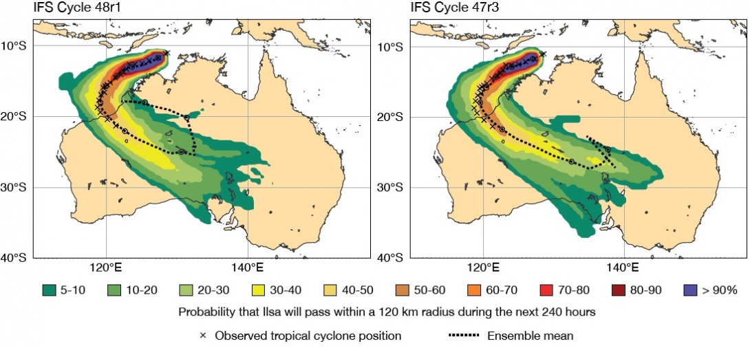
An example of the impact of the horizontal resolution increase is the case of severe tropical cyclone Ilsa, which made landfall over Western Australia in April 2023.
As can be seen in the image, the Cycle 48r1 9 km ensemble forecast initialised on 9 April provided a more accurate track forecast than the Cycle 47r3 18 km ensemble forecast.

Strike probability of tropical cyclone Ilsa, forecast from 9 April 2023, 00 UTC, in the IFS Cycle 48r1 ensemble forecast with a resolution of 9 km (left) and the IFS Cycle 47r3 ensemble forecast with a resolution of 18 km (right).
The new forecast also predicted Ilsa’s intensity much better.

The mean sea level pressure (MSLP) in the centre of Ilsa, forecast from 9 April 2023, 00 UTC, in the IFS Cycle 48r1 ensemble forecast with a resolution of 9 km (left) and the IFS Cycle 47r3 ensemble forecast with a resolution of 18 km (right).
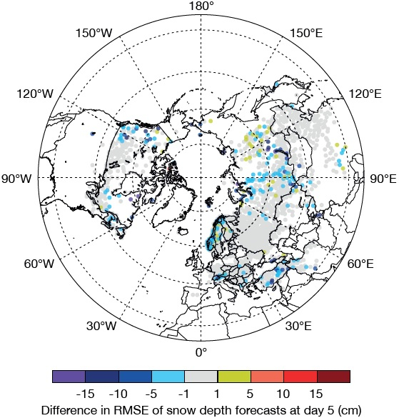
Other changes include adopting a multi-layer representation of snow rather than a single-layer representation. The multi-layer snow scheme markedly improves the realism of the snow pack in the model and leads to a reduction in forecast errors.

The figure shows the difference between multi-layer and single-layer snow in the root-mean-square error (RMSE) of snow depth forecasts at day 5, compared with SYNOP weather station values in the 2019/20 winter. Blue colours indicate an improvement when multi-layer snow is used.
In addition to predicting freezing rain, the IFS can now also predict high-impact freezing drizzle events.
Substantial changes have also been made to extended-range forecasts: they are now run daily instead of twice weekly, the number of ensemble members has been increased from 51 to 101, and they are run at a horizontal resolution of 36 km for the full forecast range, from day 0 to 46.
For details on the improvements this brings, see the web article on extended-range forecasts in Cycle 48r1.
Changes in data assimilation
Cycle 48r1 includes extensive changes to the way the initial conditions of weather forecasts are established.
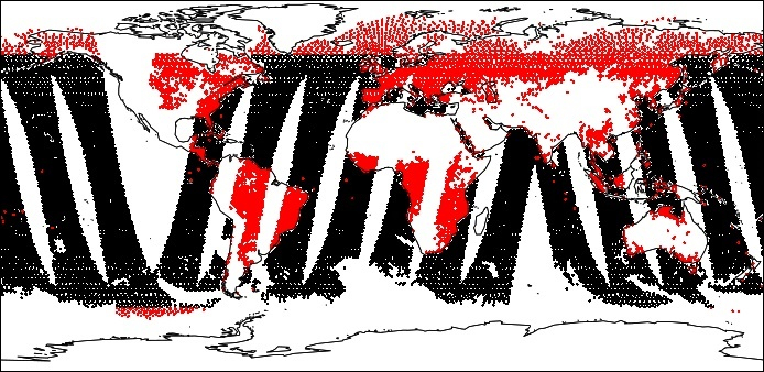
The new cycle will make better ’all-surface’ use of satellite microwave observations. The data obtained will be added to the many weather observations that help us to establish the initial conditions of weather forecasts through data assimilation.

The chart shows the coverage of observations to be assimilated in Cycle 48r1 from the Advanced Microwave Scanning Radiometer – 2 (AMSR2) in channel 11, with black dots indicating data assimilated in Cycle 47r3 and red dots the data added in Cycle 48r1. Data are for the 00 UTC cycle on 20 June 2019.
Other changes to the data assimilation system to be implemented in Cycle 48r1 include an increase in the resolution of the 4D-Var system used for the atmosphere, and a move to a new software layer called OOPS (Object-Oriented Prediction System).
Details on these changes and the improvements they bring can be found in a web article on data assimilation in IFS Cycle 48r1.
Better forecasts
The changes have resulted in better ENS and HRES forecasts right across the medium-range timeframe.
Most ENS scores of surface variables, such as 2 m temperature, 10 m wind and total precipitation, are markedly improved, in the range of 2% to 6%. Most upper-air variables are improved as well, by around 1% to 3%.
The Cycle 48r1 resolution increase improves ENS tropical cyclone track and intensity forecasts, with position errors reduced by up to 10% and core pressure errors reduced by around 20%.
Tropical cyclone track forecasts are improved because the 9 km model has a significantly reduced translation speed bias. Intensity forecasts are improved because the higher horizontal resolution allows for a better representation of the strong horizontal gradients associated with intense systems like tropical cyclones. This is also reflected in the strongly increased intensity spread of the ENS.
The changes to extended-range forecasts also lead to improvements in forecast performance, which apply across all parameters.
More details
For more details on the upgrade, see this ECMWF Newsletter article and the web page on the implementation of IFS Cycle 48r1.
