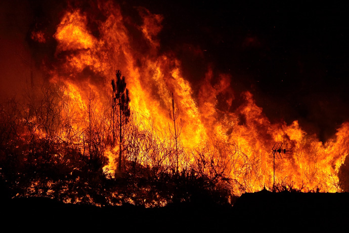

Figure 1: In recent years, hot and dry conditions have led to wildfires in parts of Europe not affected historically. (Photo: © ico_k-pax/iStock/Getty Images Plus)
Fire and water can be some of the most destructive forces on the planet. While they are a natural part of the Earth system, the risks from floods, droughts and wildfires are being altered by climate change. Exactly how are such phenomena changing? How unusual are recent events – such as the wildfires in California? To answer such questions, we need data going back in time, but observations of river flow and landscape flammability are patchy and no long-term global datasets exist.
Released this month (November 2019), the world’s first publicly available near-real-time river discharge and fire danger reanalyses will provide daily information over the whole of the globe stretching back almost 40 years. It will be an invaluable resource to help understand how unusual present-day wildfires and river flows are, and how they are changing. Such unique global reanalyses are particularly important in many areas of the world with limited in-situ observations. Furthermore, both datasets will be updated in near-real time, so people will be able to access current river flow and fire danger conditions anywhere in the world with a delay of less than one week.
The datasets are being produced by the Centre as part of its responsibilities under the Copernicus Emergency Management Service (CEMS) which is run by the European Commission’s Joint Research Centre (JRC). The Copernicus Programme is the European system for monitoring the Earth, coordinated and managed by the European Commission.
What are the new data and why are they important?
The new datasets use the latest ECMWF reanalyses (ERA5 and ERA5T for the near-real-time updates) – a blend of past weather forecasts and observations – created as part of the Copernicus Climate Change Service. Data from ERA5, such as temperature, rainfall and run-off, are fed through models of river flow and fire danger to produce historical datasets running from 1980 to the present day (Figures 2 and 3). The new reanalyses provide globally complete, daily information; it is their homogeneity in space and time which makes the new datasets so powerful.
About the new datasets
|
The datasets’ production involves several elements of the Copernicus Programme such as the European Forest Fire Information System and the Global Flood Awareness System (EFFIS and GloFAS) of CEMS, and the latest climate reanalysis (ERA5) and the Climate Data Store of the Copernicus Climate Change Service (C3S – implemented by ECMWF). Bringing these elements of the Copernicus Programme together has made the development of these reanalyses rapid and efficient and is a good example of the synergies being created within the Copernicus Programme.
Wildfire reanalyses
The fire danger reanalyses provide several indices of fire danger. They are a metric of landscape flammability which rises as ground conditions become drier, fuel (such as dead vegetation) builds up and strong winds increase the likelihood and speed of spread. Fire danger models do not predict where an ignition is likely to occur, but rather the meteorological conditions that would cause flames to spread out of control, conditional to an occurred ignition. These conditions, called ‘fire weather’, depend on atmospheric variables such as accumulated precipitation, relative humidity, temperature and wind speed.
Longer fire seasons, more heatwaves and more days without rain are all contributing to significant changes in wildfire behaviour. However, the historical data needed to assess such changes is inadequate. Thus, the new fire danger dataset will be invaluable to put into context occurring fire danger conditions in relation to what happened in the past, to assess the magnitude of climate variability and to identify changing patterns in fire-prone areas across the world. Of course, wildfires are also changing because of non-weather related factors such as housing development in wooded areas and changes in forest management.
Take the recent fires in California, the Amazon and the Arctic for example. The fire danger dataset could be used to assess whether the recent weather induced fire danger in these regions was unusually high, which might explain the fire occurrence. They could be used to look at the changing fire season in southern Europe. Has it become longer? Is fire danger becoming greater in certain areas of Europe?
Indonesia is one region known to be particularly affected by rainfall changes induced by El Niño (the tropical Pacific warming which alters patterns of rainfall across the tropics and beyond). When drier conditions result, the risks of wildfire increase. Indonesia is also a region where each year, fires are lit by people to clear land and remove agricultural residues. Where fire penetrates into degraded sub-surface peat soil, the fires can be very difficult to put out and can burn continuously until the monsoon rains return in October/November. The new dataset provides the data needed to study the links between wildfire and El Niño and other such teleconnections.
The fire danger reanalyses complement other fire-related Copernicus products, such as the biomass-burning emissions and the burnt area product made available by the Copernicus Atmosphere Monitoring Service (CAMS – implemented by ECMWF) and the Copernicus Land Monitoring Service (CLMS – implemented by the European Environment Agency and the JRC), respectively.
River flow reanalyses
The 40 years of river flow data are proving an invaluable addition to the Global Flood Awareness System (GloFAS) – the CEMS global flood service operated by ECMWF. GloFAS is an operational system for monitoring and forecasting floods across the world, designed for decision makers and forecasters in sectors such as national and international water authorities, water resources managers, hydropower companies, civil protection authorities, and international humanitarian aid organisations.
The new 40-year river flow reanalysis dataset is being used to calculate 2-, 5-, and 20-year return period flood thresholds for each grid cell across the globe. This allows the magnitude of river discharge forecasts to be directly compared to the magnitude of the long-term flood thresholds and warnings triggered as necessary.
The river flow data can also be used for assessing the global status of flood and drought conditions and for the identification of trends in key hydro-climate indices driven by climate variability and change. For example, they could help to evaluate the changing risks of low river flow which can have major impacts on water availability for agriculture, industry and energy generation and on water quality; or those of high river flows, which can lead to flooding with its obvious humanitarian, economic and infrastructure implications.
The near-real-time extension of the data will also provide a unique opportunity to monitor the status of all rivers across the world, so that it can be acted upon by users straight away, either as input to their own downstream applications, or directly based on this new information. While some parts of the world, such as Europe, have reasonably extensive observations to monitor river flow in real time, many other areas of the world do not. For those data-poor regions, the new river flow reanalyses will be particularly valuable.
How are the datasets produced?
Wildfire reanalyses
The analyses are produced by using temperature, rainfall and other data from ERA5 to drive a fire danger model which simulates the responses of fuel moisture to atmospheric forcing at different soil depths and combines these to derive fire behaviour indices in terms of ease of spread and intensity (Figure 2). The model used is the Global ECMWF Fire Forecast (GEFF) model. Within GEFF, fire weather indices are derived, based on several models such as the Canadian Fire Weather Index (FWI) System.
Within the fire danger reanalysis dataset, there are two key indices which indicate fire danger:
- Fire weather index – a generic index of fire danger calculated from how dry the fuel is, how strong the wind is, coupled with a measure of how much fuel has built up.
- Daily severity index – which gives a measure of the expected effort required for fire suppression and therefore widely used to predict the difficulty to control a fire.
The dataset has been validated against FWI values calculated from observed weather data measured at manned and automated land-based weather stations recording in 2017. The most significant errors occur for islands within the Atlantic Ocean where the FWI is largely underestimated. This is a good example of the spatial representativity issue even at the increased ERA5 resolution. While weather parameters recorded at weather stations located on small islands are representative of a land point, the model grid box (which is of order 30 km square) might also have a fraction of ocean which will contribute to a change in weather parameters towards more moist values.

Figure 2: A schematic of the production process for the fire danger reanalyses.
River flow reanalyses
The river flow data are generated by taking run-off from ERA5 and using it as input into a hydrological model. Run-off is the water (from rainfall and melting snow) that drains over the surface or within the ground and which eventually drains into the world’s river systems. In the weather forecasting and land surface model used in ERA5, run-off is calculated for each grid box, but there is no facility for run-off to flow from one grid box to another. Instead, the process of water drainage within catchments is modelled by a global, grid-based hydrological and channel routing model – LISFLOOD. LISFLOOD simulates the flow of run-off (i.e. groundwater and surface water) through catchments and the drainage of that water into river channels (Figure 3); so it provides information on daily water flux in all world rivers as represented by the 0.1° resolution of the LISFLOOD drainage network.

Figure 3: A schematic of the production process for the river flow reanalyses.
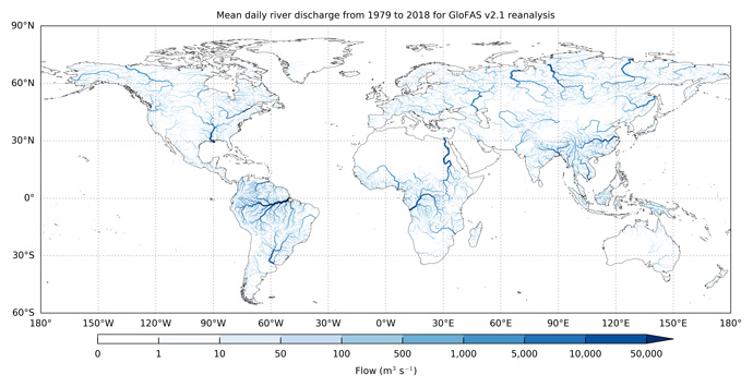
A key feature of LISFLOOD is its ability to represent features such as lakes and reservoirs that can severely alter the timing and magnitude of river discharge, albeit in a simplified way. All the world’s rivers with an upstream drainage area of more than 1,000 km2 are represented (Figure 4). However, the river flow reanalyses do not include the effects of water abstraction.

Figure 4: Daily river discharge data are available for all rivers across the world from 1980 to the present day. The figure shows daily river discharge averaged over 1979 to 2018 for each GloFAS river grid cell with an upstream area greater than 1,000 km2. Darker blue indicates larger river discharge.
The river discharge data have been validated against observations where they are available for at least 4 years over the 1979 to 2018 period. Results for overall performance show that the GloFAS river discharge reanalysis is skilful in almost 90% of catchments. The poorest performance is found across Africa.
How will the data be made available?
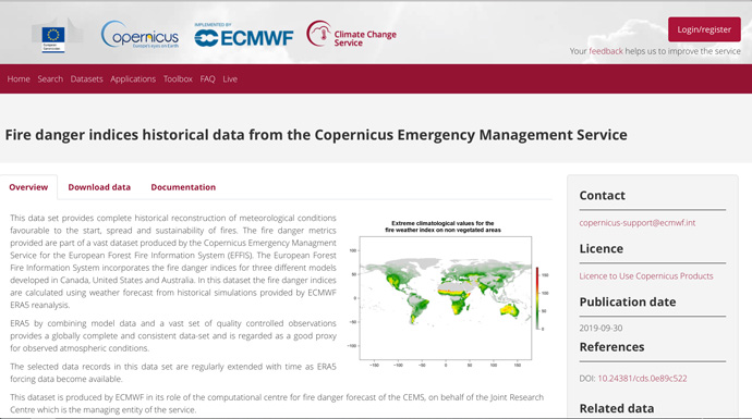
The data are being made available through the Climate Data Store which has been developed as part of the Copernicus Climate Change Service, also implemented by ECMWF. The Climate Data Store gives users an easy-to-use interface to the data (Figure 5). All data are free and available to all.

Figure 5: The fire danger and river flow reanalyses are available through the Climate Data Store, which is part of the Copernicus Climate Change Service.
