
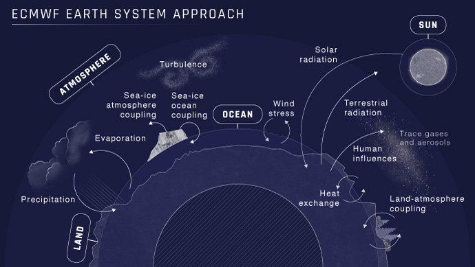
A wide-ranging upgrade of ECMWF’s Integrated Forecasting System (IFS), implemented on 5 June 2018, brings better global weather forecasts, with particularly consistent gains in the extended range. A key plank of the upgrade is enhanced dynamic coupling between the ocean, sea ice and the atmosphere.
The upgrade:
- improves forecast quality in the tropics, enabling better predictions in the extended range in Europe and elsewhere, notably at weeks three and four
- improves 2-metre temperature forecasts, including in Europe
- brings better predictions of rain in coastal areas as a result of improved cloud physics
- improves high-resolution forecasts in situations marked by rapid interactions between sea ice, the ocean and the atmosphere, such as the passage of tropical cyclones or rapid changes in sea ice cover.
Up to now, dynamic ocean, sea ice and atmosphere coupling has only been applied in medium-range ensemble forecasts (18 km horizontal resolution), extended-range forecasts and seasonal forecasts. The upgrade extends this coupling to ECMWF’s medium-range high-resolution forecasts (9 km horizontal resolution). As a result, the IFS is now more consistent and seamless across different timescales and spatial resolutions.
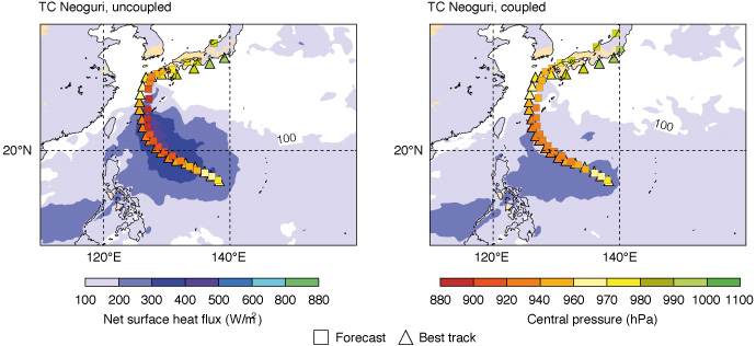
Typhoon Neoguri is an example of a tropical cyclone in which dynamic ocean–atmosphere coupling matters: a shallow warm layer in the ocean was quickly depleted, causing Neoguri to develop less deep central pressure than might otherwise be expected. ECMWF’s coupled model can represent these interactions. The plots show 5-day high-resolution track and intensity forecasts (squares) starting on 5 July 2014 together with ‘best track’ estimates (triangles) and the predicted net surface heat flux (shading) for Typhoon Neoguri using the uncoupled model (left) and the coupled model (right).
The upgrade also introduces full coupling in the tropics from forecast day 1 for both high-resolution and ensemble forecasts. Previously ensemble forecasts were fully coupled only from forecast day 4.
Partial coupling for the first four days of the forecast is retained in the extratropics. It means that sea-surface temperature tendencies are coupled with the atmosphere rather than the actual sea-surface temperature field from the ocean model.
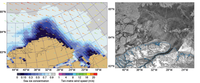
High-resolution forecasts can now reflect rapid changes in sea ice concentration. For example, the 6-day high-resolution forecast for 24 February 2018 using the coupled model (left) captured a wind-driven opening in the sea ice cover near Cape Morris Jesup in northeast Greenland (right). Wind arrows show the preceding 24-hour mean 10 m wind field. (Satellite image: European Space Agency via the Danish Meteorological Institute)
Other changes from IFS Cycle 43r3 to IFS Cycle 45r1 include:
- a better use of observations, notably through a scheme to account for the horizontal drift of radiosondes during their ascent
- the use of more satellite observations, such as non-surface-sensitive infrared channels over land and all-sky microwave sounding channels over coasts
- more realistic ocean depth (bathymetry), which mostly affects the wave fields in coastal areas
- the introduction of new products useful in the prediction of severe weather, including forecasts of lightning flash density, and of maximum convective available potential energy (CAPE) as well as CAPE-shear (CAPES) over the last six hours of the forecast.
The changes are based on research by scientists at the Centre, often in collaboration with other scientists in ECMWF’s Member States and beyond.
Accounting for the drift of radiosondes has notably been made possible by a new data format (BUFR) providing full position information that is being rolled out across the world.
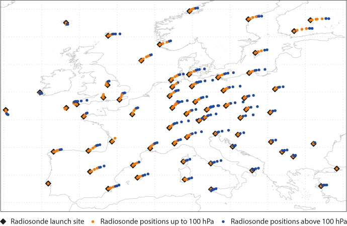
Radiosondes can drift hundreds of kilometres during their ascent. The map shows radiosonde drift over Europe in the 12 UTC analysis on 21 November 2016. Only BUFR reports are shown. Positions are shown every 15 minutes.
Director of Forecasts Florian Pappenberger said: “The new model version brings pronounced improvements in upper-air predictions in the tropics, especially for wind and temperature. It is exciting to see the consistent gains in extended-range forecasts and the overall improvement in 2-metre temperature both in high-resolution and ensemble forecasts, particularly for Europe. In addition, near-coastal precipitation in warm-rain dominated situations is significantly improved, addressing a long-standing issue with our model.”
Director of Research Andy Brown said: “This is a substantial upgrade which marks a milestone towards our Strategy to 2025. The Strategy calls for a more seamless forecasting system by making our different forecasts more coherent. The enhanced coupling across all time ranges brings us one step closer to seamlessness. In addition to the important immediate benefits the upgrade delivers, it prepares the ground for further sustained progress.”
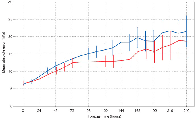
The upgrade reduces errors in high-resolution tropical cyclone intensity forecasts. The plot shows the mean absolute error of high-resolution forecasts of tropical cyclone (TC) intensity (mean sea level pressure) in IFS Cycle 45r1 (using the coupled model – red) and in IFS Cycle 43r3 (using the uncoupled model – blue). The sample comprises all TCs present at the initial time of the forecast; the sample size therefore decreases as the forecast time increases, consistent with the TC life span: it includes about 750 cases at initial time, decreasing to about 200 at forecast days 5–6 and to about 50 at day 10. Bars indicate 95% confidence intervals.
