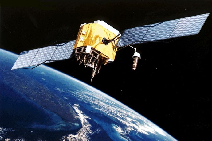

GPS satellites such as the one shown here are used in satellite-to-satellite observations of the atmosphere to support weather forecasting. (Image: NASA)
More than 100 experts meeting in Denmark from 19 to 25 September are reviewing the use of satellite-to-satellite observations of the atmosphere in weather forecasting.
ECMWF scientists attending the meeting will set out how such ‘radio occultation’ data help to define the initial conditions for forecasts and to develop forecasting systems.
The event is a joint EUMETSAT ROM-SAF and IROWG workshop. ECMWF’s Sean Healy, who co-organised it, says there is considerable scope to widen the use of radio occultation data in weather forecasting.
How the technique works
Radio occultation (RO) data are unique among the satellite observations used in weather forecasting in that they involve sending signals from one satellite to another.
The path of such signals crossing the atmosphere close to the surface of the Earth is bent as a result of refraction.
“Just like a ray of light is refracted at the boundary between air and a glass prism, so electromagnetic signals passing through successive thin layers of the atmosphere with different refractive indices are refracted,” Sean explains.
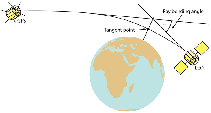
The differences in refractivity, and thus the extent to which the path of the signal is bent, depend on the temperature and humidity near the tangent point of the path (see image).
That is why the bending angle contains precious information on the meteorological conditions near that point.

GPS satellites orbit Earth at an altitude of about 20,000 km. Signals they send out are received by Low-Earth-Orbit (LEO) satellites, whose orbit is at about 700 to 800 km. When the signals pass through the atmosphere relatively close to the Earth’s surface, they are bent as a result of refraction. The resulting time delay can be measured and corresponds to a bending angle, which in turn provides information on temperature and humidity near the tangent point.
Growing importance
The first GPS-RO measurements were made in the 1990s. ECMWF started to assimilate such data in 2006 to help define the initial conditions at the start of forecasts.
Today ECMWF uses 3,000 GPS-RO profiles per day, corresponding to about 3% of the Earth system observations assimilated at ECMWF.
“The use of GPS-RO data results in a measurable improvement in forecast quality out to day 3 in the northern hemisphere and day 4 in the southern hemisphere,” Sean notes.
He believes there is scope to increase the number of GPS-RO profiles dramatically to about 20,000 profiles per day.
“Currently EUMETSAT’s Metop LEO satellites provide about two thirds of the GPS-RO data we assimilate, but six COSMIC-II US-Taiwanese satellites launched this summer have greatly boosted the available volume of data.”
Wider use of RO data
GPS-RO data are less prone to biases than other satellite measurements because they are based on the precise measurement of a time delay, which is used to derive the bending angle.
This makes such data a good standard by which errors in weather models or other observations can be measured.
Patrick Laloyaux has exploited this fact to reduce the influence of model biases in ECMWF’s data assimilation system.
The data assimilation system combines observations with short-range forecasts to arrive at an estimate of the current state of the Earth system, called the analysis.
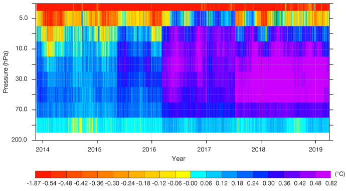
Patrick noticed that the short-range forecasts used in the data assimilation system had strong temperature biases in the stratosphere, which degraded the analysis.

Successive model changes have led to large temperature biases in parts of the stratosphere in the short-range forecasts used in ECMWF’s data assimilation system. The chart shows how such biases have evolved since 2014 as measured against GPS-RO data.
“We have successfully used the information from GPS-RO data to reduce the impact of model biases in the data assimilation system,” he says.
Patrick notes that the change is due to be implemented in the next upgrade of ECMWF’s Integrated Forecasting System. “This is a nice example of how GPS-RO data can be used not just as observational input to improve the analysis, but also to detect and help remedy shortcomings in the forecasting system.”
