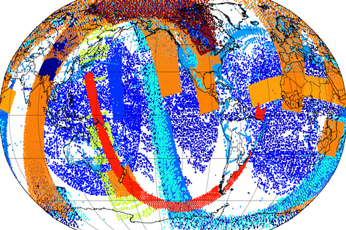

Example of extra observations assimilated in a single data assimilation cycle as a result of changes in ECMWF’s Integrated Forecasting System being implemented on 11 June.
ECMWF is implementing a substantial upgrade of its Integrated Forecasting System (IFS) today, 11 June 2019, which will significantly improve global medium-range weather forecasts. One of the key novelties in IFS Cycle 46r1 is that it makes data assimilation more continuous.
Other notable changes include the introduction of a 50-member Ensemble of Data Assimilations; the use of weakly coupled data assimilation for sea-surface temperature in the tropics; and improvements in the wave model, the convection scheme, the radiation scheme and the use of observations.
The changes bring substantial improvements in the skill of the Centre’s ensemble forecasts (ENS) and higher-resolution deterministic forecasts (HRES), extending the time for which skilful forecasts can be made by up to 3 hours.
The IFS is upgraded regularly, typically once or twice a year, to implement improvements made possible by the latest scientific advances.

The upgrade substantially improves the prediction of ocean waves. (Photo: andrej67/iStock/Getty Images)
Continuous data assimilation
One of the main drivers of the improvements in forecast skill in IFS Cycle 46r1 is the move towards more continuous data assimilation.
Data assimilation combines short-range forecasts with observations to obtain an estimate of the current state of the Earth system. This estimate, called the analysis, is used as the starting point for forecasts. The quality of the analysis is thus crucial for successful weather forecasts.
The new, more continuous data assimilation framework enables more recent observations to influence the analysis. This is achieved by continuing to feed new observations into the system even after the iterative data assimilation calculations have begun, almost right up to the start of the forecast calculations.
The change also means that more accurate data assimilation configurations can be accommodated inside the operational schedule.

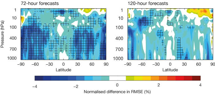
Continuous data assimilation reduces forecast errors, as shown in these plots of zonal (east–west) mean difference in root-mean-square error (RMSE) between forecasts of vector wind with and without the change, verified against the operational analysis. Negative values indicate smaller RMSE when using continuous data assimilation. Hatched areas indicate statistically significant changes at the 95% confidence level. The plots are based on six months of experimentation covering December 2016 to August 2017.
The upgrade also increases the number of members of ECMWF’s Ensemble of Data Assimilations (EDA) from 25 to 50. The increase in ensemble size improves both the high-resolution analysis and the EDA-based perturbations to the initial conditions for the 50‑member ensemble forecast.
More details on these changes can be found in ECMWF Newsletter articles on continuous data assimilation and the 50-member EDA. An animation on continuous data assimilation is also available.
Wave model changes
Wave forecasts benefit from new parametrizations for wind input and deep-water dissipation of waves as previously implemented by Météo-France, based on work by Fabrice Ardhuin (Ifremer, France) and collaborators.
The changes have been adapted to run efficiently in the IFS. They improve forecasts notably by reducing the energy of waves that have travelled a long way from where they were generated, and by slightly increasing wave height in the extratropical storm tracks.
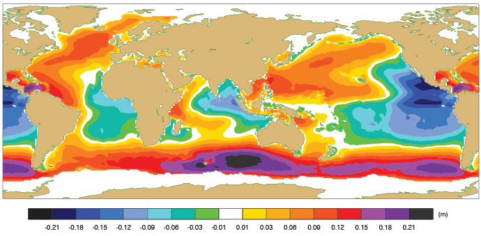
The result is that significant wave height – a widely used sea-state parameter which is roughly the average height of the highest one third of waves – is generally reduced in the tropics and increased in the extratropics. In the HRES, significant wave height and mean wave period are improved by 5–10%. More details can be found in a Newsletter article on the changes.

Annual mean difference in significant wave height between the new and old wave physics. The data are from standalone wave model runs with atmospheric and ocean variables provided by the ERA5 reanalysis.
Better forecasts
IFS Cycle 46r1 brings substantial improvements in forecast skill for both ENS and HRES. In the extratropics, medium-range forecast errors are reduced by 1–5% for upper-air and by 0.5-2% for surface parameters. In terms of lead time, upper-air improvements amount to a gain of around 2–3 hours.
Precipitation forecast skill increases in the extratropics by about 0.5% in the ENS and 1% in the HRES. Other weather parameters, such as 2-metre temperature and 2-metre dewpoint, 10-metre wind speed, and total cloud cover improve by about 1% in the ENS, and by 0.5-1% in the HRES when verified against observations.
Results in the tropics are more mixed, but there are strong improvements for 2-metre temperature. Tropical cyclone forecast skill is neutral overall, with a slight reduction in track error, consistent with improved winds in the tropics.
Futher information
More details can be found
- on the IFS Cycle 46r1 implementation web page for forecast users
- in the 15 May webinar on the improvements brought by IFS Cycle 46r1
- in the 7 March webinar on what’s new in IFS Cycle 46r1.
