David Lavers, Scientist, Forecast Department
Flooding has wide-reaching and devastating impacts on European society and beyond. Its effects include loss of life, the displacement of people, harmful psychological impacts, structural and financial losses, and damages to agriculture and the environment. From 1980 to 2016, economic losses of 450 billion euros were reported in the 33 European Economic Area member countries due to weather- and climate-related extremes, and approximately 40% of these losses were from floods.
In the public’s view, there has also been a perception of an increasing number of floods over the last 20 years, with the Elbe and Danube basin floods in summer 2002, and the wet winters of 2013/14 and 2015/16 in Northwest Europe being notable examples. What is worse is the potential for increasing flood risks in the future as the global water cycle intensifies in response to climate change.
Clearly, there is an imperative for ECMWF to improve the predictability of extreme events, such as floods, and this is a research priority over the next decade.
Flood forecasting tools at ECMWF
Flooding can be classified as:
- pluvial - when heavy rainfall overwhelms the local drainage system,
- fluvial or river - when a river goes out of bank,
- groundwater - when the water table rises to affect an area, and
- coastal - when a storm surge inundates a coastal area.
All of the above types (and a combination thereof) occur across Europe, but the focus here is on pluvial and fluvial types.
At ECMWF, there are currently three key tools used to raise awareness of pluvial and fluvial flooding and these are the:
- Extreme Forecast Index (EFI),
- Shift-of-Tails (SOT), and
- European and Global Flood Awareness System (as part of the Copernicus Emergency Management Service).
The EFI and SOT compare the forecasts of precipitation (and other variables) with the climate of the Integrated Forecasting System, which gives an indication of how extreme the forecasts are. For the EFI, the value ranges from -1 to 1, with -1 indicating extremely low and 1 indicating extremely high forecast values compared to the climate.
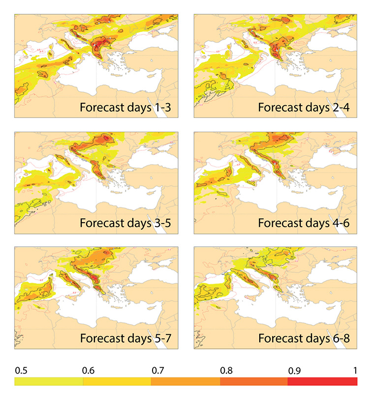
The figure below gives an example of the EFI and SOT for precipitation for the Balkans flooding in November 2016 at multiple lead times. This devastating event had a clear signal, indicated by the red areas in the figure. A risk of extreme precipitation can be seen 6 to 8 days in advance (bottom right panel). The signal of extreme precipitation intensified as the forecast lead time reduced.

An example of the precipitation Extreme Forecast Index (EFI) (shading) and Shift-of-Tails (black contours) for 6 to 9 November 2016 at multiple lead times. Red shading shows regions most vulnerable to extreme precipitation.
ECMWF is also the computational centre for the European Flood Awareness System (EFAS), which uses ensemble precipitation forecasts as input to a hydrological model to forewarn of river flooding. If floods are forecasted, warnings are disseminated to the relevant hydro-meteorological agencies, so that preparations can be made.
Improving flood forecasts and their uptake
One of ECMWF’s objectives is to improve predictions of extreme events, and flooding is a key area.
For example, part of my research is looking at the Extreme Forecast Index (EFI) and extending its use to atmospheric water vapour fluxes. In recent research the winters of 2015/16 and 2016/17 were studied, and over Europe (and western North America) the EFI for water vapour flux appears to be more skilful than the precipitation EFI for forecast lead times of a week or more. It is the large-scale nature of these fluxes, their higher predictability, and their relationship with extreme precipitation that result in their potential usefulness in these regions, which, in turn, could provide earlier awareness of extreme precipitation.
ECMWF is also a partner in two European Union Horizon-2020 projects which aim to improve the skill and, just as importantly, the operational uptake of precipitation and flood forecasts. ANYWHERE (EnhANcing emergencY management and response to extreme WeatHER and climate Events) and IMPREX (IMproving PRedictions and management of hydrological Extremes) are complementary projects that will facilitate better risk management in exposed communities.
Understanding the characteristics of European floods
Across Europe, floods can have diverse characteristics depending on both local weather and the nature of the land surface.
In European winters, the passage of North Atlantic low-pressure systems can result in fluvial flooding. Within these Atlantic storms, atmospheric rivers, or narrow bands of intense water vapour flux, are known to be responsible for extreme precipitation and flooding, as with storm Desmond in the north-western British Isles in December 2015. Conversely, in summer, pluvial flooding connected to thunderstorm (or convective) activity is more dominant. Areas such as Genoa in Liguria, Italy, are vulnerable to these floods, and Livorno experienced a devastating event in September 2017 in which there were six fatalities. In northern Europe in eastern Scandinavia, the hydrological regime is one in which fluvial flooding occurs in late spring and early summer and is largely caused by snowmelt.
Surface permeability, land use, lakes and reservoirs, and terrain all act to attenuate the transport of rainwater to the river network, which affects the resulting flood. In urban areas and steep mountainous terrain, a rapid response to precipitation can occur, and Genoa is a place where the terrain contributes to its vulnerability. In regions with substantial groundwater storage capability or lakes, a slower response generally results, with the rainwater sometimes taking months or even years to move through a river basin.
There are, however, large intra-regional differences in flooding properties. For example, Sweden has a rapid response to precipitation in the western mountains, whereas the east has an attenuated precipitation-flooding signal due to snowmelt.
At ECMWF our research aims to understand these characteristics and represent them more accurately, to develop effective flood forecasting tools and to work with users to ensure effective communication, planning and response.
Banner photo: SlobodanMiljevic/iStock/Thinkstock
