Gianpaolo Balsamo, ECMWF Principal Scientist, Earth system modelling and coupled processes
Being capable of anticipating the adverse, and equally, the favourable effects of the weather, can enhance the quality of life and bring competitive advantage to a number of economic sectors. Storms or persistent droughts bring hazards for example, and favourable weather can be associated with enhanced productivity (e.g. good agricultural yields, safe road conditions, convenient shipping routes, tourism activities). This drives a growing demand for accurate global weather forecasts and for monitoring locally relevant changes in weather patterns associated with a changing global climate.
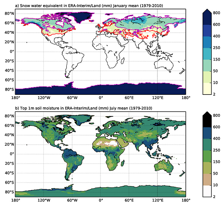
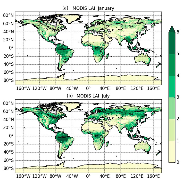
A rising awareness of this demand is guiding development at ECMWF towards improved fidelity of physical processes in our models, timeliness of forecasts, and validity at increasingly longer lead-times. The forecasts include not only weather elements, but also more and more surface environmental conditions (such as soil water content, snow cover and vegetation-state, Figures 1 and 2) and their coupled effects on near-surface temperature, humidity, and the airflow.

Figure 1: Water content in the snow-pack in January (a) and in top 1-metre of soil in July (b) as derived from monthly climatology provided by ERA-Interim/Land (1979-2010).

Figure 2: Vegetation-state map expressed as Leaf Area Index (m2/m2) in January (a) and July (b) provided by NASA-MODIS satellite as used at ECMWF and verified with LST data.
Two-way coupling between the Earth’s surface and atmosphere
It is well known that atmospheric extremes, manifesting into high-energy or persistent weather conditions, affect the state of the Earth surface and thus where we live. However, what is not yet fully appreciated and understood is how much the surface influences the atmosphere in a fully-fledged two-way coupling.
We do know that surface conditions, such as soil moisture and sea-surface temperature, can affect the atmosphere. They change slowly and so have “memory”, which can be utilised to enhance predictability (Dirmeyer et al. 2015). Earth surface conditions in numerical weather prediction and climate models are subject to a variety of assumptions and simplifications in representing natural and anthropogenic surface elements. The land and ocean models we use aim to represent both short-lived and long-memory processes that can provide useful predictable signals (from minutes to months and beyond) and are particularly important in the medium range, 10 to 15 days ahead (Balsamo et al. 2017).
Enhanced estimates of land-surface characteristics
The land surface modelling system, as used for instance for the ERA-Interim/Land dataset, has provided an improved reanalysis of land-surface parameters for 1979-2010 (see Figure 1, for example). This represents an invaluable resource for analysing trends and initialising past re-forecasts. The methodology used (Balsamo et al. 2015) continues to support the research-to-operational transfer of updates in Earth surface modelling in the ECMWF Integrated Forecasting System (IFS) and new climate reanalyses (e.g. ERA5). Updates cover areas such as lake modelling, enhanced multi-layer surface enhancements, updated physiography, and upgraded model grid definitions.
The methods used for ERA-Interim/Land have also been applied in the European H2020 project EartH2Observe (E2O). This is focusing on global water resource estimates using a variety of European land surface and hydrological schemes (Schellekens et. al. 2017) and producing a coordinated set of simulations enhanced by the use of Earth observations, via calibration or data assimilation. Such research is helping to support EU policy to safeguard Europe’s water resources, and identify water crises at global to local scales, thanks to a chain of models at different resolutions.
Some of the major European integrated land-modelling systems (CHTESSEL, JSBACH, JULES, LPJGUESS, ORCHIDEE, SURFEX, TERRA, etc.) participated with their Offline Modelling Systems to contribute to a multi-model ensemble dataset available on the Water Cycle Integrator portal (WCI). ECMWF continues to support this research generating adapted meteorological boundary conditions connected to both reanalysis and forecasts.
The human influence on the Earth’s surface
Humans affect the Earth’s surface, through land-use and coastal modifications, for example. Including more of such human-related effects, which can influence surface fluxes to and from the atmosphere, represents a shared challenge ahead for the Earth system modelling community. This is recognised within the World Climate Research Programme Grand Challenges (WCRP-GCs).
Monitoring human activities and their impact on the Earth system will require increased use of Earth observations that are currently not yet fully exploited. This will drive the demand for future satellites, enabling research to respond to multiple questions:
- How much will weather forecasts be affected by a more precise and updated description of the Earth’s surface?
- At which forecast range are these processes most relevant?
- How much impact can we expect from human activity sectors for instance in industrial, commercial and residential areas?
- How will this impact the weather and climate of the future?
A number of exciting projects and programmes we have engaged with are paving the way to a future in which more surface processes will be represented, and the human modifications to the Earth system will be better accounted for. The effects on surface fluxes and reservoirs (e.g. for water, energy, carbon cycles) will be monitored pretty much like temperature, winds and precipitation are nowadays.
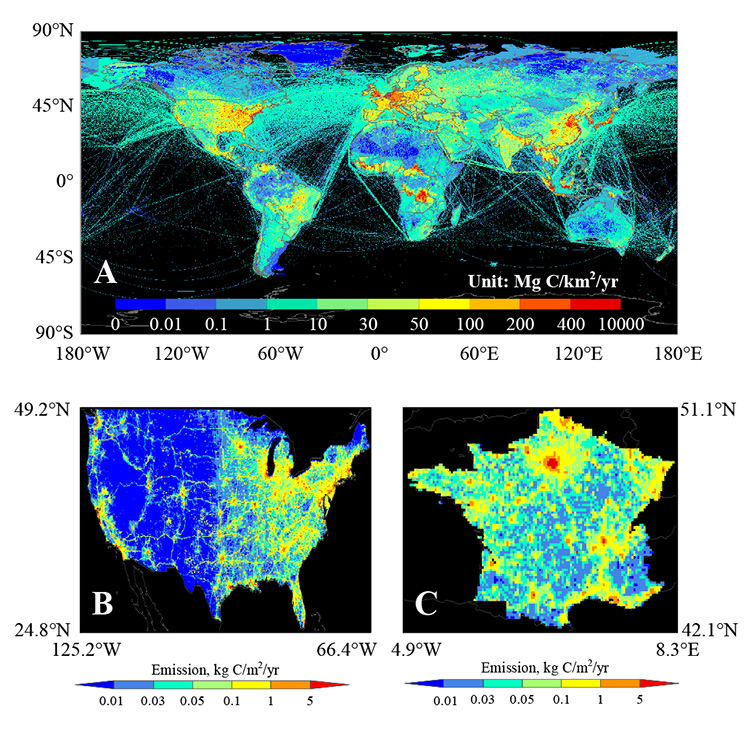
An initiative in this direction is the European CO2 Human Emission H2020 project (CHE) in which CO2 global forecasting capabilities (Agustí-Panareda et al. 2014) will be expanded to account for up-to-date surface emissions and assimilating available remote-sensing and in-situ observations. CO2 is first of all an observational challenge (Ciais et al. 2014, Figure 3), and information gathered within the CHE project will aim at guiding development towards a monitoring and verification that can support the implementation of the Paris Climate Agreement. Leading experts in academia, research institutes and industry are putting together their expertise to design and dimension a future service.

Figure 3: Examples of fossil fuel emission maps obtained from global/national inventories.
Transferring research into operational use
The pathway to transfer this research into operational daily use is yet to be fully defined and it is what drives me the most as a scientist, because again it relates to the processes. Designing, developing and deploying a system that can enable and support innovative uses and applications is not only a professional responsibility, but part of the fun and excitement that will involve team efforts.
