 |
 |
Jonny Day, Forecast Department, Evaluation Section and Gabriele Arduini, Research Department, Earth System Modelling Section
Snow plays a crucial role in weather and climate, particularly in high latitude and high altitude regions which are covered in deep snow either permanently or for large parts of the year. It is an important reservoir of fresh water for drinking and agriculture, and dramatically influences surface meteorology. Flooding associated with rapid snow melt also poses significant hazard to human life. It is, therefore, crucial for weather and hydrological forecasting at ECMWF that forecasts of snow and its influence on the weather are well captured in the forecasting system.
Currently, most operational numerical weather prediction (NWP) models use only a single-layer snow scheme, which is thought to contribute to systematic temperature biases in ECMWF forecasts in high latitude regions, including Northern Europe during winter and spring (Arduini et al., 2019). Using a single-layer snow scheme can also lead to errors in the simulation of snow depth and cover. For example, during spring, the single-layer scheme contributes to sluggish snowmelt. This leads to errors in hydrological forecasting but also to errors in temperature, by delaying the transition to snow-free conditions in the forecasts.
A state-of-the-art multi-layer snow scheme has been implemented in an experimental version of the Integrated Forecasting System (IFS) as part of ECMWF’s contribution to the WMO’s Year of Polar Prediction (YOPP) and the H2020-APPLICATE project which is expected to improve this situation. It is currently under testing within the 4-dimensional variational (4D-Var) data assimilation system and is expected to become operational in a forthcoming operational upgrade.
Here we present some examples of the improvements the new snow model will bring to ECMWF forecasts, focused on Northern Europe. This provides an opportunity to showcase the excellent work done by the Finnish Meteorological Institute (FMI) in collecting rich meteorological data at Sodankylä, a snow covered boreal site in Finnish Lapland (e.g. Essery et al. (2016) and Leppänen et al., (2016)) and highlight their use at ECMWF.
Improved 2 metre temperature forecasts in the medium range
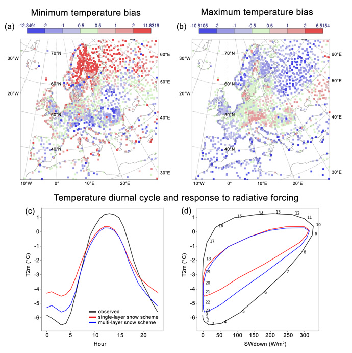
A warm bias in night-time temperatures and a cold bias during the day is a long-standing error in the IFS in Northern Europe during spring (Figure 1a, b and c). Further analysis at Sodankylä reveals that this underestimation of the amplitude of the diurnal cycle of 2 m temperature is due to a lack of sensitivity to changes in radiation in the IFS (Figure 1d). This lack of sensitivity is partly due to the use of the single-layer snow model in which the entire snowpack is represented by one layer and so a large thermal inertia can result if the snow pack is deep, as is the case in Scandinavian regions during winter and early spring (see ECMWF Newsletter, Haiden et al. (2018)).

Figure 1: Top: spatial map of March–April daily minimum (a) and maximum (b) temperature error for the ECMWF operational system at a lead time of 2 days. Bottom: (c) March–April mean diurnal cycle of 2 m temperature at Sodankylä in observations and in the ECMWF forecasting system with single-layer and multi-layer snow. (d) Mean temperature for each hour of the day as a function of downwelling shortwave radiation (numbers on the observed curve represent the hour of the day in UTC).
Introducing the multi-layer scheme reduces these errors by increasing the amplitude of the diurnal cycle of temperature (Figure 1c). This is because directly representing a thin top layer of snow, with a lower thermal inertia, makes the surface and near-surface air temperature more sensitive to variations in radiative forcing than is possible with the single-layer scheme, making the simulation more realistic. This increase in sensitivity (leading to more rapid warming in the morning and cooling in the evening) can be seen nicely by looking at how 2 m temperature responds to variations in radiative forcing (Day et al., 2020), such as the diurnal cycle of solar radiation (Figure 1d).
Realistic vertical snow structure
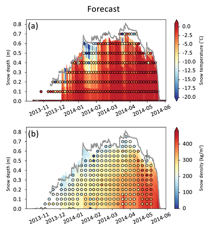
When adding a new Earth-system component to the forecasting system, it is also important to understand the changes at the process level. Figures 2a and 2b show time-height plots of snow temperature and density at Sodankylä, from observations and from forecasts coupled to the multi-layer snow model. Snow temperature is measured by an array of thermistors which is covered by the snow during wintertime, while snow density profiles are measured every week or so by digging a pit in the snow and weighing a snow sample of a certain volume at different depths (see Figure 2c).
The multilayer snow model captures the propagation of hot and cold waves within the snowpack, which is a key feature of deep snowpacks. Comparison of the modelled temperature with observations suggests that the downward propagation of this cold wave through the snowpack is well represented by the model. The temporal evolution of snow density also looks realistic throughout the season (see Figure 2b), even though the snow density of the bottom of the snowpack is overestimated by the model, particularly after February.

(c)
Figure 2. Top: comparison of coupled atmosphere multi-layer snow forecasts (coloured shading) with in-situ snow temperature (a) and snow density (b) measurements (coloured dots) (from Arduini et al. (2019)). The observed snow depth is shown with a grey line. Bottom: picture of manual snow survey taking place (photo courtesy of Anna Kontu, FMI). Figures 2 a & b reproduced under Creative Common Licence CC BY 4.0.
These results highlight the motivation and the impact that the new snow model is expected to have on ECMWF forecasts. They also provide an excellent example of how process-oriented evaluation of model developments at supersites, such as Sodankylä, helps to ensure that model developments are improving forecasts for the right reasons. However, clearly there is more to do to understand and improve systematic forecast errors at this complex site, where interplay between snow, forest and atmosphere create a complex web of interactions. Work to further understand the sources of error at Sodankylä, and other Arctic sites will be conducted as part of INTERACTIII.
References
Top banner image: © Liubov Yashkir / iStock / Getty Images Plus
