

Angela Benedetti and Julie Letertre-Danczak, Earth System Assimilation Section. Mark Fielding and Marta Janisková, Earth System Modelling Section.
Fifteen years ago, on April 28 2006, the Cloud-Aerosol Lidar and Infrared Pathfinder Satellite Observation (CALIPSO) satellite was launched. Despite its mission lifetime being estimated at just three years, the satellite is still flying around the Earth today, at an altitude of 705 km and offering an unprecedented view of the horizontal and vertical structure of aerosols and clouds.
CALIPSO is a joint US (NASA) and French (Centre National d’Etudes Spatiales/CNES) venture and was a founder member of the ‘A-train’ constellation of satellites, so called due to the local time of overpasses from their ascending orbits occurring in the afternoon.

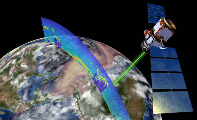
Figure 1: The so-called ‘Godzilla’ dust outbreak on 22 June 2020: CALIOP observations of lidar backscatter superimposed on CAMS operational forecasts of total aerosol optical depth (pink and yellow) and total cloud water (white). Image of satellite from: https://science.nasa.gov/multimedia-galleries/spacecraft-icons/
Cloud information from CALIPSO
At ECMWF, cloud observations from CALIPSO have proved invaluable for the validation of model cloud fields and recently have even shown potential to be used in initialising forecasts via data assimilation.
CALIPSO carries an active lidar instrument (CALIOP) and passive infrared and visible imagers. The pulses of light emitted by the lidar are strongly reflected by cloud droplets and ice particles, which allows the lidar to detect the vertical extent of clouds with an extremely high precision. These vertically resolved observations began to be exploited in 2008 for validation of cloud top heights, thus providing insight regarding boundary layer depths and the mixing of air at cloud boundaries. Another use was to improve the representation of super-cooled liquid clouds that are abundant over the Southern Ocean. For more than a decade, a climatology of CALIPSO cloud amount has been used to evaluate new model cycles of the ECMWF Integrated Forecasting System (IFS). The CALIPSO data can uniquely highlight model deficiencies, particularly for remote regions of the Earth that are not covered by surface-based observations.
To utilise cloud lidar observations for data assimilation, a forward model was developed, which simulates the lidar backscatter from modelled clouds. Recent feasibility studies with the four-dimensional variational data assimilation scheme (4D-Var) have shown that, in combination with cloud radar reflectivity from CloudSat (CALIPSO’s sister satellite in the A-train), CALIPSO cloud lidar backscatter has a direct positive impact on medium-range forecast skill.
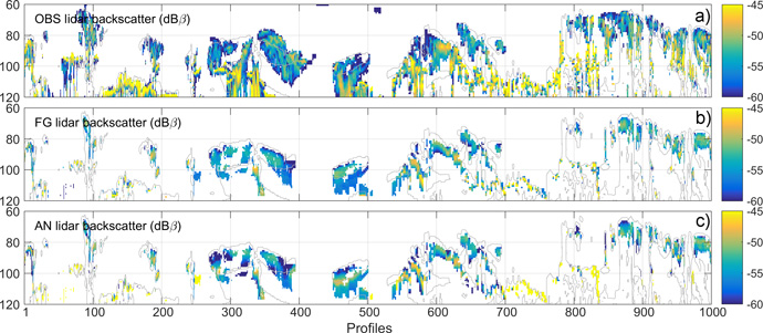
As shown in Figure 2, the assimilation system combines the first guess (FG) and observations to generate the analysis (AN), which is a closer fit to the true cloud fields. The assimilation of CALIPSO and CloudSat data produces adjustments to temperature and humidity in the model’s initial state, and so improves the representation of clouds. It is these adjustments of atmospheric variables at the start of the forecast that lead to improvements in medium-range weather prediction. Though the radar information provides the largest single impact, it is the synergistic combination of radar and lidar that provides the greatest total impact.

Figure 2: Cross-sections of cloud lidar backscatter [dBβ; log10(m-1 sr-1)] corresponding to an orbital track on 31 July 2007 at 21 UTC. Panels show (a) observed CALIPSO lidar, (b) first guess (FG) and (c) analysed (AN) model lidar backscatter coming from the model analysis obtained by assimilation of cloud radar and lidar observations on top of all routinely assimilated observations. The FG lidar is only displayed where there are hydrometeors detected in both model and observations. The FG model cloud boundaries are shown in grey.
Aerosol information from CALIPSO
CALIPSO has also been a game changer for aerosol assimilation applications. The operational Copernicus Atmosphere Monitoring Service (CAMS) aerosol analyses and forecasts are based on the assimilation of total column data from imagers. These data are extremely useful, but do not provide information on the vertical structure of the aerosol fields or the location of an aerosol plume. Volcanic eruptions are a particular example for which it is very difficult to estimate the altitude of the emitted plume. This often results in misplacement of the aerosols in the vertical and consequently inaccurate plume advection. Knowing the altitude of the volcanic plume allows us to correctly estimate the trajectory, which is important for aviation for example.
In 2012 some preliminary assimilation studies using CALIPSO aerosol lidar data were performed using what would become the CAMS system. The initial developments were based on an observation operator which allowed the conversion of aerosol concentrations into backscatter signal, which is what is measured by CALIOP. These initial studies have allowed us to continue to develop the assimilation system and perform more experiments, for example related to the 2010 eruption of the Eyjafjallajökull volcano in Iceland, using a combination of ground-based and satellite information. Thanks to the profiling capabilities of the instrument, the data improved the vertical location of the volcanic plume, allowing a better model performance. Today, CALIPSO is still used in assimilation studies as well as for verification to evaluate the skill of the aerosol model in the IFS.
Outlook
The heritage from CALIPSO has also contributed to the success of aerosol assimilation studies using more recent instruments such as the Doppler Wind lidar on board of the ESA Aeolus satellite. Originally designed for wind-only applications, Aeolus is also providing aerosol and cloud data which are being exploited to improve aerosol analyses. The expected launch of the EarthCARE satellite in 2023, which will also carry a lidar instrument for cloud and aerosol observations will enable the continuation of many years of work on cloud and aerosol modelling and assimilation which have prospered from the successful CALIPSO mission.
