
El Niño conditions in the central Pacific are now reaching very strong values, and further maturing of the El Niño event is expected in the coming months.
An El Niño event is a prolonged period of abnormally high sea-surface temperatures (SST) in the tropical Pacific Ocean.
SST anomalies are currently comparable to those of the record-breaking 1997 event in the central tropical Pacific, but they are significantly smaller near the coast of Peru.
Recent observations
Relative to the 1981–2010 average, the sea-surface temperature anomaly in the NINO3.4 region has increased substantially since July, with the August value just over 2 °C. This is consistent with last month’s forecast, and it is the warmest August value on record (a fraction ahead of the 1997 value in the dataset we use, although the difference is within measurement error).
In the far eastern Pacific (NINO1+2) it is a different story – anomalies are quite large, but much smaller than in 1997.

Average sea-surface temperature anomalies in August 2015. The chart shows SST anomalies compared to the 1981–2009 average.


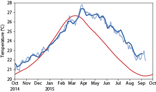
Average and observed sea-surface temperatures in the NINO1+2 region. The charts show the average evolution of sea-surface temperatures in the NINO1+2 region based on the years 1981 to 2010 (red line) together with the observed evolution between October 1996 and October 1997 (left-hand panel, blue line) and since October 2014 (right-hand panel, dark and light blue lines, representing two different analyses). The difference between the red and blue lines is the sea-surface temperature anomaly.
Latest forecasts
The latest forecasts suggest that SST anomalies in the central Pacific will continue to increase, albeit at a more moderate pace, peaking around December. As discussed in last month’s El Niño update, the ECMWF model can overestimate anomalies in exceptional events. In any case, there remains uncertainty due to the influence unpredictable details of the weather will have on the ocean.
The event will be very strong, with an SST anomaly of more than 2 °C in the NINO3.4 region, but whether it reaches the values seen in 1997 remains to be seen.

ECMWF plume of NINO3.4 sea-surface temperature anomalies. The chart shows an ensemble of predicted SST anomalies over the NINO3.4 region produced on 1 September from the ECMWF model. Ensemble forecasts account for the uncertainties inherent in the prediction of weather and ocean parameters by producing a set of possible outcomes.
An interesting contrast with 1997 is the evolution of SST in the far eastern Pacific, near the coast of Peru, as monitored by the NINO1+2 index.
Forecasts for NINO1+2 suggest that anomalies may grow in the coming months but are expected to stay below the very high values (exceeding 4 °C) seen in 1997.
This El Niño event is expected to be a little more central-Pacific-focussed than that of 1997, but it should be noted that the spread in NINO1+2 temperatures is large, and the anomalies may still turn out to be the second highest on record.

ECMWF plume of NINO1+2 sea-surface temperature anomalies. The chart shows the predicted SST anomalies over the NINO1+2 region produced on 1 September from the ECMWF model.
