
The question of which aspects of the weather can be predicted up to three months ahead was the subject of an international workshop held at ECMWF from 2 to 5 November.
Beyond about a week the skill of weather forecasts for a particular location and a specific time can tail off quickly. But that does not mean that we cannot say anything about the following few weeks or months.
We may, for example, be able to predict with some confidence that the weather in Europe will be warmer over the next three weeks than the average conditions for this time of the year. Or colder, or drier, or windier.
Such predictions are called sub-seasonal forecasts as they cover timescales up to a season. They typically concern average conditions over a region, such as a country, and a period of time, such as a week.
The information they contain may be of great interest to sectors such as agriculture, energy, health and emergency management.

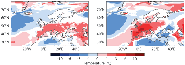
These 2-metre temperature forecasts initialised on 18 June and 22 June 2015 show the difference between predicted and average climatological temperatures for the period 29 June to 5 July 2015, which marked the start of a protracted heat wave in many parts of Europe. The 2-week forecast (left) already predicts warmer than average conditions for that period, and the 1 1/2-week forecast (right) is even closer to the observed conditions (not shown). In the white areas, the forecast is not significantly different from average climatological conditions.
Earth system approach
Such predictions can be made because there are large-scale features of the Earth system whose longer-term evolution is more predictable than local and time-specific aspects of the weather.
These include stratospheric conditions, soil moisture, snow, sea ice and sea-surface temperature as well as some large-scale weather patterns.
A prominent example of the latter is the Madden-Julian Oscillation (MJO), a travelling pulse of cloud and rainfall near the equator, mainly over the Indian and Pacific Oceans. It moves eastwards and propagates around the globe in about 30 to 60 days.
Forecasters have developed charts that visualise its predicted progress.

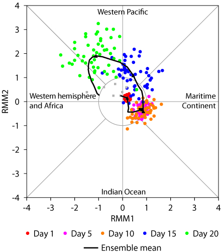
The dots in this forecast of a strong MJO event show the progression of the active phase of the MJO over a period of 20 days from 26 February 2015, as predicted by different members of an ensemble of forecasts. The quadrants indicate the location of the active phase and the distance of the dots from the centre represents its predicted strength. The solid line, which represents the ensemble mean forecast, suggests that the active phase of the MJO will strengthen as it moves from the Maritime Continent (comprising Indonesia, the Philippines and Papua New Guinea) into the western Pacific, before subsiding again as it moves over the western hemisphere.
MJO events can influence local weather patterns. Tropical cyclones, for example, are more likely to occur during the active phase of the MJO, when the frequency and intensity of deep convection are enhanced compared to average conditions.
But MJO events can also cause shifts in atmospheric circulation in other parts of the globe. Such repercussions are known as ‘teleconnections’.
“Significant improvements”
Scientists at the workshop on ‘Sub-seasonal Predictability’ held at ECMWF presented their latest research on teleconnections and other sources of predictability. The event attracted 57 speakers and participants from 15 countries.
Sub-seasonal forecasts rely on the same kind of Earth system models and numerical methods as weather and climate predictions at other timescales. A number of speakers discussed model performance and presented examples of successful international collaboration.
“The workshop showed that there is growing interest in sub-seasonal prediction by the research and application communities, which is partly motivated by significant improvements in the predictive skill of the MJO,” said Frédéric Vitart, one of the organisers of the event.
There were interesting discussions on how to:
- better understand the physical processes relevant for this time range
- configure sub-seasonal forecasting systems
- enhance international collaboration.
In particular, there are plans to collaborate on establishing a common protocol to validate and assess forecast performance. During this workshop it was recognised that a lot of progress has been made at this time range, but more will be required to achieve better sub-seasonal predictions, in particular in the mid-latitudes.

The workshop brought together more than 50 scientists from 15 countries.
