
Unusual weather satellite data over a large swathe of the Indian Ocean can be attributed to emissions from Indonesian wildfires, it has emerged.
In early September, satellite data normally used to determine temperature and humidity showed a striking thermal radiation pattern over the Indian Ocean.
An analysis of the pattern suggests that it was caused by unusually high concentrations of hydrogen cyanide (HCN) in the atmosphere.
HCN is a pollutant which is known to be produced by biomass burning. Scientists at the EU-funded Copernicus Atmosphere Monitoring Service run by ECMWF confirm that HCN emissions from Indonesia are the likely cause of the anomaly.
Mystery signal
Meteorological satellites play a vital role in modern weather forecasting. They provide a unique global view of atmospheric conditions, particularly over oceans, where other types of observations are impractical. In particular, they can provide vital early warnings of severe weather events.
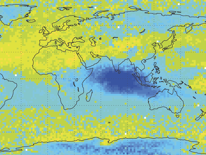
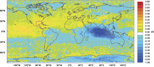
In partnership with the EUMETSAT-funded NWP-SAF, ECMWF operates a highly sophisticated automated monitoring system that checks hundreds of millions of satellite observations every day searching for small anomalies in the data. In early September, data from European and American infrared satellites pointed to a significant event over the Indian Ocean (Figure 1).

Figure 1 In early September, METOP-A satellite data showed an anomaly in infrared observations at the wavenumber 713 cm-1 (corresponding to a wavelength of 14 microns) over the Indian Ocean. The chart shows monthly mean values for the period 15 September to 15 October 2015.
The instruments on board these satellites are designed primarily to provide information on variations of temperature and humidity by measuring fluctuations in the natural thermal radiation emitted by the Earth’s atmosphere. However, it soon became clear from the spectral characteristics of the signal that this anomaly could not be attributed to any meteorological event.
The timing of the peculiar signal coincided with widely reported wildfires in Indonesia. Could part of the cocktail of gases and particulate pollutants produced by these fires be responsible for influencing the weather satellite measurements, and if so, which? The hunt was on for the source of the mystery signal.
When ECMWF presented the anomaly to a small group of scientists at a recent conference, HCN was suggested as a possible culprit. This pollutant is a well-documented product of biomass burning. But did its known spectral fingerprint match that of the signal detected in the satellite observations?
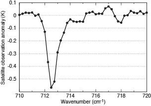
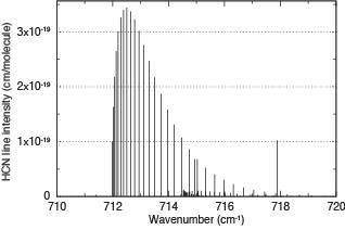
Independent checks at ECMWF, NCEP, Université libre de Bruxelles (ULB) and the UK Met Office all confirm a near perfect match (Figure 2).


Figure 2 Spectral characteristic of the observed satellite anomaly showing the satellite measurement depletion (left); and spectral fingerprint of HCN determined from laboratory measurements showing the strength of HCN absorption (right).
Furthermore, preliminary calculations suggest that the atmospheric concentration of HCN over large areas of the Indian Ocean, far away from the original source of the pollution, may be as high as 20 times the normal background value.
Regional issue
Mark Parrington from the Copernicus Atmosphere Monitoring Service confirms that, while HCN is not routinely monitored, high values of a range of other pollutants associated with biomass burning have been observed extending across the Indian Ocean for a number of weeks, where they are rapidly lifted to the upper troposphere.
“Our analyses and forecasts have been showing emissions from Indonesian wildfires to be a significant regional issue in recent weeks,” he says.
Products available on the service’s website include global forecasts and analyses of reactive gases and aerosols in the atmosphere. Recent analyses continue to show, for example, high concentrations of carbon monoxide and biomass-burning aerosols in the region of Indonesia.
