
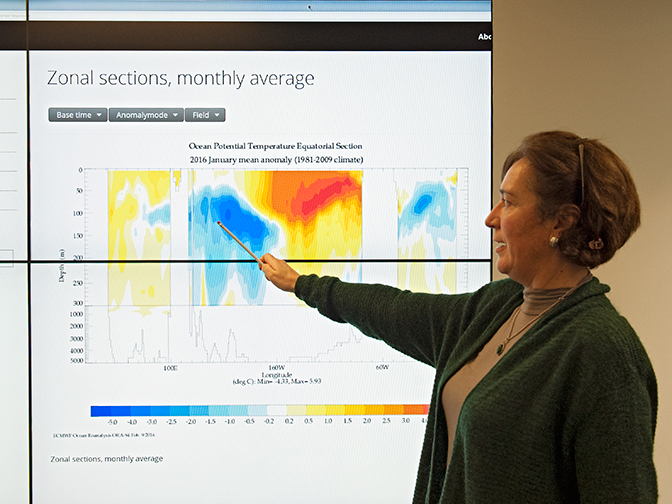
The use of ocean models at ECMWF started in 1995, when the Centre decided to develop an experimental programme of seasonal prediction.
Ocean expert Magdalena Balmaseda has been closely involved in these activities from the beginning.
Her PhD and post-doctoral work was on dynamical systems, including the El Niño–Southern Oscillation (ENSO).
It gave her just the right kind of expertise to help get the Centre’s newly formed Seasonal Forecasting Group off the ground.
ECMWF’s first steps in seasonal forecasting coincided with the occurrence of the massive 1997/98 El Niño. The successful prediction of this event and its impact over Europe opened the door to much more ocean-related work in ECMWF’s research and operational activities.
It was known that at seasonal timescales predictability depends on the successful modelling and initialisation of ocean processes.
Soon it became evident that the ocean also contributes to predictability on monthly timescales. It also became clear that the problem of seasonal prediction was far more challenging than originally anticipated.
There is now a growing realisation that even in some relatively short-lived weather events, such as hurricanes, modelling the interaction between the ocean and the atmosphere is vital if predictions are to improve.
The ocean work started by the seasonal forecasting team back in the nineties is therefore far from finished.
Ocean modelling
In many ways ocean modelling is similar to atmospheric modelling. Like the atmosphere, water is a fluid whose behaviour can be described by fluid dynamical equations.
These equations can be solved on powerful computers using suitable numerical methods. The solutions can be used to simulate the evolution of ocean currents, temperature and other parameters.
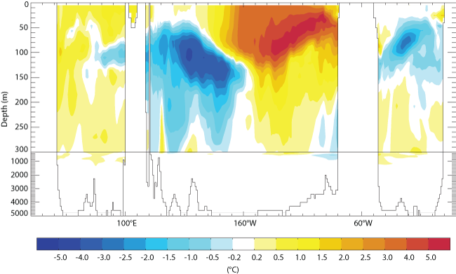
Temperature is an important ocean parameter. The chart shows the mean ocean potential temperature anomaly in cross section at the equator in January 2016. It is marked by strong anomalies of opposite sign in the Pacific Ocean. The warm anomalies in the eastern Pacific are linked to the current El Niño event. The cold anomalies to the west may gradually move eastwards and rise, causing a cooling of sea-surface temperatures in the months to come. The chart is one of several ocean reanalysis charts published on ECMWF's website.
But there are also some important differences.
“The main differences are that the ocean is not compressible, with much higher density and heat capacity than the atmosphere, and that it is strongly stratified in the vertical: the ocean is heated from above while the troposphere is heated from below. As a consequence, the timescales involved in the ocean are longer and the dynamical spatial scales range from very small to very large,” Dr Balmaseda explains.
The range of relevant parameters is also different: there are for example no clouds in the ocean, but there are different levels of salinity, which affects density and thus contributes to deep convection.
Impact of the ocean
It has long been known that the ocean plays a decisive role in the climate system since it is an important regulator for the energy, water and carbon cycles. The slowness of ocean processes is largely responsible for the long timescales characteristic of internal climate variability.
But this alone does not make ocean processes relevant to weather prediction. Indeed, until recently medium-range weather prediction ignored ocean processes, on the assumption that at timescales of days the ocean has infinite heat capacity.
It was only in 2014 that ECMWF included the ocean in its medium-range/monthly ensemble prediction system.
The interest in the ocean came from the idea that slow variations in the ocean state may modify large-scale atmospheric circulation and the probability of different weather patterns occurring around the world.
Slow variations in the ocean at seasonal timescales are in principle predictable, but making such predictions requires the modelling and the initialisation of the ocean and its interaction with the atmosphere.
“For timescales from months to a few years, you really need to include ocean dynamics, which provides predictability by virtue of being slow,” Dr Balmaseda says.
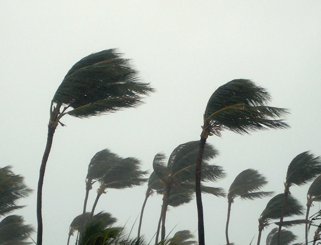
Ocean conditions can influence the strength of tropical cyclones. (Photo: Thinkstock/iStock/RamonBerk)
The initial focus at ECMWF was on predicting conditions in the tropical ocean, especially those associated with El Niño, which can have a strong impact on the atmosphere across the globe via ‘teleconnections’.
Once a coupled ocean–land–atmosphere prediction system was ready for seasonal forecasts, it was natural to start exploring the role of other ocean processes at shorter lead times.
It turned out that using a coupled model also led to more accurate predictions not only at monthly timescales, but also in the medium range. And as more and more observations become available, including from satellites, scientists are increasingly becoming aware of interactions between the atmosphere and the ocean at even smaller scales.
An example of this is the upwelling of ocean water associated with tropical cyclones. The water pumped to the surface at the centre of a tropical cyclone tends to be colder and may weaken it.
“If this effect fails to be taken into account, high-resolution atmospheric models can overpredict the strength of tropical cyclones,” Dr Balmaseda points out.
Today ECMWF uses ocean modelling in its seasonal, monthly and medium-range ensembles, and plans are under way to incorporate it into high-resolution forecasts.
Estimating the current state of the ocean
Using ocean models in prediction systems requires observations of ocean parameters and a data assimilation system. These are needed to produce an estimate of the current state of the ocean, which is used to initialise a forecast.
The frequency and density of observations of the ocean have grown immensely over the last few decades, but they still can’t rival the amount of data available for atmospheric parameters.
“One reason is that the electromagnetic radiation on which satellite measurements rely cannot penetrate into the ocean, so satellite instruments can only observe surface parameters,” Dr Balmaseda notes.
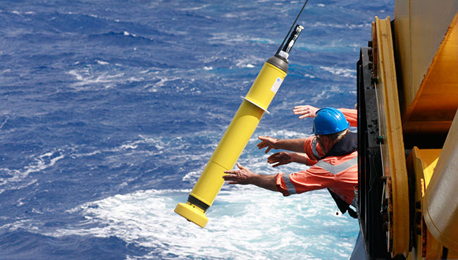
An Argo float is deployed into the ocean. Today thousands of Argo floats provide a high-density observation network across the globe for ocean parameters to a depth of 2,000 metres. (Photo: CSIRO)
Observations come from a variety of sources. Traditionally these have included probes dragged by ships.
Starting in the eighties, the Tropical Atmosphere Ocean (TAO) array was set up in the tropical Pacific. Later renamed TAO/TRITON, this fixed network of some 70 buoys measures sea-surface temperature, surface winds and the thermal structure of the upper ocean. This observing system played a key role in the initial efforts to develop seasonal forecasts.
More recently, 3,000 free-floating instruments have been deployed across the world’s oceans to provide measurements to a depth of 2,000 metres. The information collected by these ‘Argo floats’ is transmitted to satellites when they surface.
Towards Earth system modelling and assimilation
One of the main challenges facing numerical weather prediction is to model the interaction between different parts of the Earth system, including the atmosphere, oceans, land surface and sea ice, at all relevant scales.
A second major challenge is to understand how best to estimate the current state of the coupled ocean–land–atmosphere system to start coupled forecasts.
Waves are a special case in that they have a model of their own. This was initially only coupled with the atmospheric model, because of the interaction between waves and winds. Now ECMWF’s wave model is also coupled to the ocean model, which is in turn coupled to the atmospheric model.
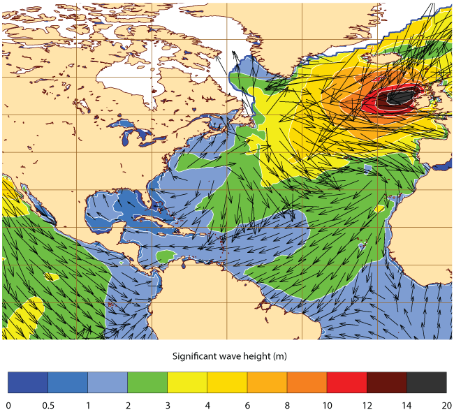
Wave height predictions are part of ECMWF’s suite of forecast products. The chart shows part of a global 108-hour forecast of significant wave height and mean direction for 12 UTC on 1 February 2016. It shows predicted significant wave heights of between 14 and 20 metres near the coast of Ireland.
“Soon sea ice will be introduced into the medium-range/monthly ensemble, which is a very exciting development, and we hope to be ready to contribute to the International Year of Polar Prediction,” Dr Balmaseda says.
Work on coupled data assimilation is currently focused on the production of an Earth system reanalysis, a major undertaking with “tantalising first results”.
According to Dr Balmaseda, ECMWF has come a long way towards developing a fully coupled unified system, but a lot of work remains to be done.
The new structure of ECMWF’s Research Department will help drive this process forward. In particular the new Earth System Predictability Section, which Dr Balmaseda heads, will explore which other components of the Earth system need to be included in order to improve ECMWF’s predictions and extend the range of useful predictive skill.
“Pioneering work exploring the impact of ozone and aerosols is being carried out by members of the Section,” Dr Balmaseda notes.
However, using Earth system models for weather prediction will require changes in software infrastructure and ways of working with other organisations.
"It would be difficult for a single centre to specialise in all relevant parts of the Earth system. That is why the future of Earth system modelling at ECMWF will heavily depend on collaboration with other organisations.”
ECMWF scientists are at the cutting edge of research and operations in all aspects of numerical weather prediction. This is the first in an occasional series of articles highlighting their expertise in a range of areas.
