
A collaboration between ECMWF scientists and the Red Cross Red Crescent Climate Centre is investigating how forecasts of flash floods can help the communities likely to be affected.
Such partnership between scientists and humanitarian organisations is critical to developing an effective forecasting system and to ensure that potential victims of flooding can benefit from life-saving forecast information.
Flash floods happen quickly and can occur almost anywhere. Their rapid onset makes them a deadly risk. Flash floods happen when rainfall is so heavy that the water cannot drain away and it flows rapidly across the land surface. Flood water can quickly inundate homes and buildings and carry debris in its path.
Tragically, the death toll from such events can be high, especially in less developed countries which may lack effective local warning systems and have limited capacity to respond to an impending disaster.
The deadly nature of flash floods makes them one of the priorities of the European Centre for Medium-Range Weather Forecasts (ECMWF) as part of the Copernicus Emergency Management Service.

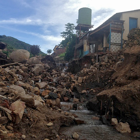
Damage wrought by flash floods in the Chilobwe Township of Blantyre in southern Malawi during January 2015. (Photo: Andrew Kruczkiewicz)
Developing an effective forecasting service needs an understanding of how authorities and the general public might use that forecast information to help them prepare, as well as the ability to predict the physical hazard itself.
This is why collaborations with partners like the Red Cross Red Crescent Climate Centre are so important to ECMWF as it develops forecast products for severe weather events.
Calum Baugh is working on flash floods at ECMWF and is collaborating with Andrew Kruczkiewicz, researcher at the International Research Institute for Climate and Society (IRI), Columbia University, and Science Advisor for Climate Risk and Flood Management at the Red Cross Red Crescent Climate Centre.
Calum Baugh commented: “Organisations like Red Cross Red Crescent National Societies have a huge wealth of data and experience in dealing with hazards such as flash floods. Combining these with ECMWF forecast data gives the best chance of creating warning products which are both accurate and readily understandable.”
Initially the partners in this collaboration are trying to piece together a more detailed picture of the flash floods that have occurred in the past, as the observations going back in time are very patchy. This lack of observations is hampering efforts to understand where, why and how often flash floods strike.
Once the historical picture of flash floods has been built up, the partners will begin to explore trends within the dataset. For example, are flash floods concentrated in particular regions, or at particular times of the year?
Then ECMWF reanalysis data will be used to investigate linkages between flash flood trends and weather variables, with the aim of identifying new ways of predicting flash floods.
Tricky forecasts
While ECMWF already provides regular forecasts of river flooding, forecasting flash flooding is more of a challenge.
Rivers tend to flood in response to rainfall over a wide area, and river waters rise relatively slowly over hours to days.
Flash floods, on the other hand, are typically caused by a sudden, heavy and localised downpour of rainfall and depend on the detailed state of the land surface. Each event tends to be unique. The unique and highly localised nature of flash floods makes them harder for global-scale forecasting models to predict.

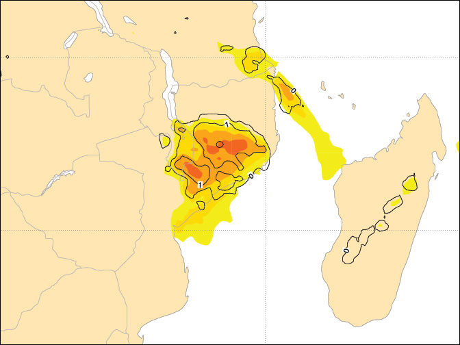
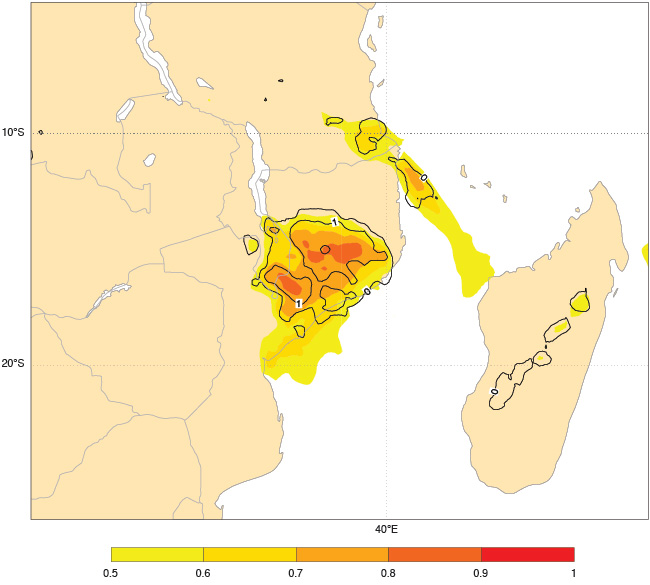
ECMWF forecasts suggested unusually heavy rainfall over Malawi and Mozambique on 12 January 2015, indicated by the orange/red areas in the chart. This was largely consistent with the onset of heavy rains which led to subsequent flooding. The chart shows ECMWF's Extreme Forecast Index (EFI, shading) and Shift of Tails (SOT, contours) forecast from 00 UTC on 12 January 2015 for total precipitation over the next 24 hours. EFI values close to 1 indicate a high probability of extreme weather. High SOT values indicate the possibility that an exceptional event may occur.
Using novel ways to forecast flash floods, such as those being developed in this collaboration, could provide one way forward.
During a recent visit to ECMWF, Andrew Kruczkiewicz said: “The Red Cross Red Crescent reaches out to the most vulnerable, aiming to decrease the impact of natural disasters, including flash floods.
“Working with ECMWF provides a great opportunity to explore flash flood forecasts on the medium-range timescale. Coupled with IRI’s experience on the seasonal timescale, we believe this is a step towards understanding the potential to link preparedness actions for flash floods to forecasts across various timescales.”
He added: “From forecast development to dissemination and action, it is important for humanitarian actors to link with scientists as much as possible. Doing so increases trust, and thus action, leading to a higher potential for decreasing impact in the most vulnerable communities.”
Effective preparation
At all stages of the work, the partners involved will always come back to key questions that help communities prepare effectively. How are communities affected by flash floods? If forecast information were available, what action could communities take and how much warning would they need?
The Red Cross Red Crescent may identify that communities need a week or more to prepare for a flood, for example. Scientists can then go back to look at flood forecasts and see the skill they have at this timescale. ECMWF’s focus on the medium term and beyond is of particular benefit here.
Information can also be provided about the level of confidence in a forecast, because of the ensemble system used by ECMWF, where multiple forecasts are run from slightly different initial conditions. If many ensemble members are pointing towards flash flood conditions, then this suggests a high level of confidence. Such information is vital to humanitarian organisations.
Ultimately the aim of the collaboration is to develop a forecast-based financing system for flash floods.
ECMWF forecasts of river flooding are already contributing to a pilot forecast-based financing system through the Global Flood Awareness System (GloFAS) in collaboration with the Joint Research Centre of the European Commission supported by the Copernicus Emergency Management Service (Early Warning Systems).
A forecast-based financing system releases funds for preparedness actions when forecasts predict that flooding is likely. It enables aid agencies to help local people prepare ahead of flooding and to assist with any evacuations. While it cannot stop the flooding, it could reduce damage and crucially save lives.
