

The EU-funded Copernicus Climate Change Service (C3S) operated by ECMWF is trialling a multi-system seasonal forecast service.
Behind the scenes, ECMWF scientist Eduardo Penabad Ramos helped to prepare the ground for the successful launch.
Eduardo is at home both in the science of meteorology and in setting up the technical systems required to run a forecasting service.
After a first degree in physics, he completed a Master’s in ocean and atmospheric modelling. He went on to work in numerical weather prediction at the Spanish regional meteorological service MeteoGalicia for nearly 13 years, including a stint as a weather presenter on regional and national TV.
He also co-founded a private weather company. This led him to hone the technical skills needed to develop user-friendly forecast products.
Eduardo’s work in the C3S Seasonal Forecast team since November 2015 has been similarly hands-on.
“The forecast models included in the new C3S service are all well established, and a lot of work to bring them together in a multi-system framework had already been done at ECMWF for the EUROSIP initiative. The focus of my work has been to develop this into a more public-facing, user-oriented service,” he explains.
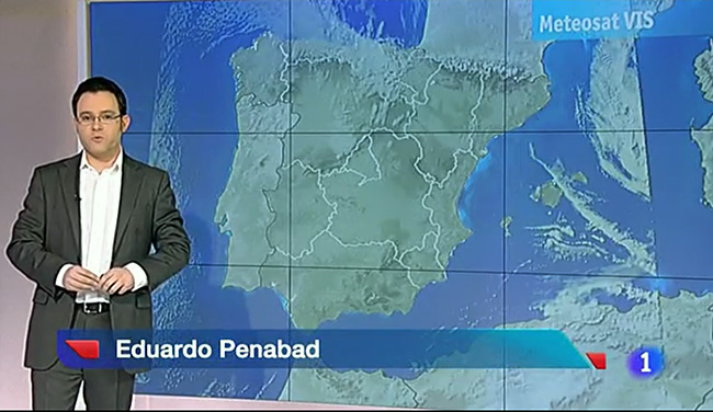
Eduardo’s varied career includes working as a weather presenter for Spanish regional and national TV. (Image: TVE news bulletin)
What are seasonal forecasts?
Unlike weather forecasts, seasonal forecasts do not describe future weather conditions at a particular location on a given day. Instead, they enable an estimate of the likelihood that conditions in the upcoming season will be different from the usual conditions for that time of year.
“They may predict that on average conditions in a given region will be a bit cooler or drier than usual without making any predictions for specific times or locations,” Eduardo says.

Seasonal forecasts can be of interest to a wide range of users, for example in the energy, water and agricultural sectors. (Photo: Taglass/iStock/Thinkstock)
The reason that such forecasts can be made at all is that certain slow-varying, predictable, large-scale ocean and atmospheric phenomena are known to influence the weather on relatively long timescales, he explains.
“They work like the weights in loaded dice, making some numbers more likely than others. This gives us some ability to assess the likelihood of different scenarios.”
An important example is the year-to-year variations in sea-surface temperature and atmospheric conditions that can be observed over the tropical eastern Pacific Ocean.
These variations, known as the El Niño–Southern Oscillation (ENSO), can have strong repercussions on global weather patterns.
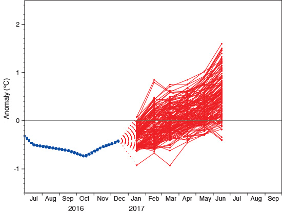
The C3S multi-system sea-surface temperature anomaly forecast for the NINO3.4 region in the tropical Pacific from 1 January 2017 shows a transition from the recently observed La Niña conditions (blue dotted line) to neutral or weak El Niño conditions for next summer. The forecast combines output from the seasonal forecasting systems at ECMWF, the UK Met Office and Météo-France.
Why multi-system forecasts?
The C3S seasonal forecast service brings together forecasts from ECMWF, the UK Met Office and Météo-France.
Two additional providers, Italy’s Euro-Mediterranean Center on Climate Change (CMCC) and Germany’s National Meteorological Service (DWD), will start submitting data in the course of 2017.
Each model simulates the Earth system processes that influence weather patterns in slightly different ways, leading to different kinds of model error.
“In seasonal forecasts, the accumulated model errors become significant in comparison to the signal that is meant to be predicted. Some of those errors are shared by the different models but others are not, so combining the output from a number of models enables a more realistic representation of the uncertainties due to model error,” Eduardo says.
“Studies have shown that, in most cases, such combined forecasts are more skilful than forecasts from the best of the individual models,” he observes.
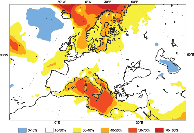
This C3S multi-system forecast from 1 January 2017 for the months of February, March and April shows the probabilities that 2-metre temperatures will be in the highest 20% of the climatological spread of temperatures for that time of year. The forecast combines the output of seasonal forecasting systems at ECMWF, the UK Met Office and Météo-France.
Combining the data
Data from different models can only usefully be combined if they are structured in a similar manner.
For example, ECMWF and Météo-France simulate model errors and uncertainty in the initial state by running an ensemble of 51 slightly different forecasts on the first day of each month. The UK Met Office, on the other hand, runs two forecasts initialised every day of the month.
The models also differ in the way their reference climate is determined. ECMWF and Météo-France work with a fixed reference climate, produced using their respective seasonal forecast system in advance of producing the forecasts. The UK Met Office produces a new reference climate for each set of forecasts to take account of any changes in its model.
“One of the big challenges over the last few months has been to process the data from the different models in a way that makes them compatible,” Eduardo notes.
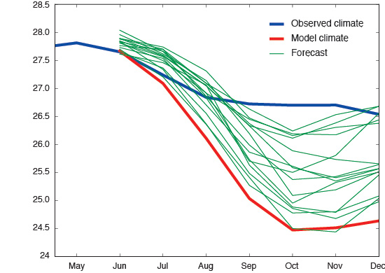
Seasonal forecasting systems work with a reference climate to determine how predicted values differ from what is normal for a given region and time of year. In order to eliminate systematic model error (bias), the reference climate is based on forecasts for earlier years (‘re-forecasts’ or ‘hindcasts’) produced with the same forecast system. This ‘model climate’ may well be different from the observed climate. In the chart above showing sea-surface temperature forecasts in the NINO3.4 region, the predicted values fall below the observed average climatological values, which could suggest relatively cold, La Niña conditions. However, they remain above the model climate’s average values, which shows that, after accounting for model bias, the prediction is for relatively warm, El Niño conditions.
The way ahead
The C3S seasonal forecast service is currently in transition from the proof-of-concept phase to a pre-operational stage.
Ultimately a data service will make all output available in the C3S Climate Data Store.
“Information about the skill of the forecast system is essential for the sensible use of the forecast products, so evaluation procedures will have to be implemented,” Eduardo says.
“In Europe, in particular, seasonal forecast skill can be low, so it will be essential for us to be very clear in the way we communicate uncertainties.”
In addition to verification scores and statistics, new products will progressively be developed.
“This service is meant to meet the needs of its users, so we are looking forward to receiving feedback on the initial-release products currently available on our website.”
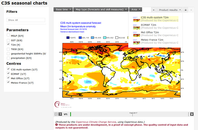
A prototype multi-system seasonal forecast service is now available on the C3S website.
