

Michael Rennie, Scientist, Earth System Assimilation Section, and Lars Isaksen, Principal Scientist, Earth System Assimilation Section
After finally overcoming the technical difficulties of a UV lidar in space, the European Space Agency (ESA) Earth Explorer satellite mission Aeolus is planned to be launched on 21 August 2018. Aeolus carries an active remote sensing instrument (a Doppler Wind Lidar) to provide the world’s first globally distributed direct horizontal-wind information profiles from space.
Aeolus fires UV laser pulses into the atmosphere and measures the change in frequency of the backscattered light (Doppler shift) due to the motion of the scatterers. The light is backscattered from atmospheric air molecules, clouds, aerosol and the ground. The Doppler shift is converted to a line-of-sight speed, which after various corrections, e.g. for satellite-Earth relative motion, provides the atmospheric wind speed, along the direction of the laser pulse.
Being a lidar, Aeolus has a good vertical resolution, but cannot penetrate through optically thick clouds. The bulk of the wind observations will be available from clear air, and the rest are from within optically thin clouds (e.g. cirrus) and aerosol and from the top of optically thick clouds. The maximum vertical coverage will be from the surface up to around 30 km.
ECMWF has been closely involved with the mission, right from the design phase until the upcoming operational phase. This is because the winds are important for weather prediction. We believe that Aeolus, as an Earth Explorer, can demonstrate a useful positive impact on NWP forecasts, particularly via data assimilation of the winds to improve initial conditions. Additionally, the novel wind information may help to diagnose systematic errors in the forecast model, which may lead to model improvements.
ECMWF is in the unique position of being a major part of the Aeolus mission’s Ground Segment, and in this role will operationally produce the mission’s main product: Level-2B (L2B) horizontally projected line-of-sight (HLOS) winds. This L2B product will be applied by NWP centres around the world to improve weather forecasts and used in meteorological research more generally. The L2B processor has been developed via funding from ESA for more than a decade by the L2B team, which is a collaboration between ECMWF and the Dutch national meteorological service, KNMI.
Why are Aeolus winds needed?
The data assimilation of meteorological observations is a critical step in the generation of accurate weather forecasts by getting the best possible initial conditions. The current global observing system is significantly lacking in directly observed wind information; the coverage is much better for the mass-related (temperature) observations, particularly from the abundance of passively sensed radiance observations. The actively sensed lidar line-of-sight winds from Aeolus will fill a significant gap in the wind observing system, particularly in the upper troposphere, the lower stratosphere, in the tropics and over the oceans, where in situ wind observations are lacking. A limitation of Aeolus observations relative to in situ wind observations is that they only provide the component of the wind vector along the line-of-sight, hence we rely on variational data assimilation to determine the wind vector in the analysis.
We particularly expect Aeolus winds to significantly improve the tropical analysis — an area where the model winds are known to have the largest errors. Dynamical arguments and experiments with real in situ wind data have demonstrated that wind information is more important than the mass information for determining the atmospheric state in the tropics and for smaller horizontal scale dynamical features in the extra-tropics.
Aeolus’ expected life-time of three to four years may be relatively short, but it is an Explorer mission intended to demonstrate the impact of Doppler wind lidar from space. If ECMWF and possibly other NWP centres can demonstrate a positive impact from using Aeolus winds, then this mission will be deemed successful, and it should pave the way for an operational follow-on mission. The wind profiling gap in the observing system is unlikely to be filled by other data types.
What impacts might Aeolus data have?
We have been investigating the expected data coverage of Aeolus winds. Since the Aeolus instrument has not been launched yet, we have used model-derived data as a proxy to simulate Aeolus inputs to our L2B wind processing software.
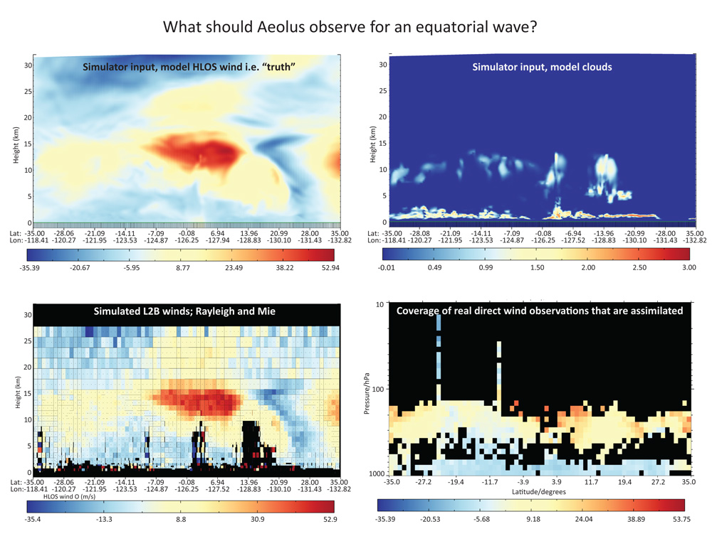
Figure 1 shows an example for the tropics, a region where Aeolus data are expected to provide most impact. The example is for a case on 15 March 2014 looking at a roughly south to north cross-section in the tropical east Pacific. Uncertainty in this particular upper tropospheric wind jet is thought to have contributed to a significant ECMWF forecast failure over Europe.

Figure 1: Top row: Model-derived inputs (taken as “truth”) for the Aeolus simulation. Top-left: horizontal line-of-sight (HLOS) wind field. Top-right: optical properties (i.e. where the clouds are). Bottom-left: simulated L2B wind product. Using ECMWF model fields as input to the Aeolus end-to-end simulator to generate realistic raw data. The raw data is then put through the actual Aeolus Ground Segment processing chain to produce the L2B product. Bottom-right: what the current operational observing system provided in terms of direct wind observations.
You can see from Figure 1 that the simulated Aeolus derived L2B winds provide a much more complete picture of the jet (red and orange region in Figure 1 bottom left) than is possible with our current available direct wind observations alone (Figure 1 bottom right). In the above example, Aeolus has the potential to significantly improve the wind analysis in the tropical upper troposphere and lower stratosphere by filling in large gaps in the observing system. The global distribution of the direct wind observations is very variable, as shown in Figure 2. There are large regions with very few wind observations.
")
Figure 2: Illustration of the direct wind observing system that is assimilated at ECMWF from late 2016 (the coverage of wind observations for assimilation is very similar today). LWDA = long window data assimilation. AMVs = atmospheric motion vectors (winds derived from tracking features in geostationary satellite imagery).
ECMWF’s operational Level-2B wind processing
As mentioned above, ECMWF will operationally generate the L2B HLOS wind product as part of the Level-2 Meteorological Processing Facility, which is funded by ESA. ECMWF will receive the input products (Level-1B data and calibration data) from ESA/ESRIN (ESA Centre for Earth Observation) in near-real time and process to L2B products within minutes. The L2B products will be immediately converted to BUFR format for distribution around the world (with the aid of EUMETSAT). The distribution will start when the quality is deemed acceptable by ESA and ECMWF.
ECMWF will also produce a key input for Aeolus’ Ground Segment: the auxiliary meteorological dataset (AUX_MET). The clear-air (Rayleigh) winds of Aeolus have a sensitivity to atmospheric temperature and pressure, which is corrected for in the L2B processing. Hence, this is one of the reasons why ECMWF is so closely involved in the Ground Segment processing, as we can provide the accurate temperature and pressure forecasts for this correction.
ECMWF, along with our L2B team partner KNMI, has also been developing the L2B processing software. So, for this demonstration mission of Aeolus, it is important for ECMWF to be closely involved in developing the algorithms after launch and in determining appropriate settings to maximise the impact for NWP usage. Further information can be found on the Level-2B processor package page.
We will also carefully monitor the Aeolus data against our NWP model equivalents i.e. departures relative to the background and analyses, which will allow us to quickly understand any problems in the data. We will assess the quality of the Aeolus data during the Commissioning Phase (the first 3 months after launch) and into the Operational Phase, in collaboration with the CAL/VAL (calibration/validation) teams (including other NWP centres). Once Aeolus data has reached a good quality, then we will perform Observing System Experiments, in which it will be determined if assimilating Aeolus provides benefit. If all goes well we shall operationally assimilate Aeolus — hopefully this will not be too far into the mission’s lifetime.
If Aeolus is assimilated then ECMWF will also produce an L2C product, which consists of the vector winds from the analysis at the geolocations where L2B HLOS winds have been assimilated and hence have strongly influenced the analysis. The L2C vector winds are a mixture of information from the background forecast, other observations and Aeolus.
Aeolus has been in development for over a decade and we look forward to seeing the benefits it can bring.